Meziměstí | |
|---|---|
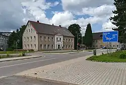
 Town centre with the town hall | |
 Flag  Coat of arms | |
 Meziměstí Location in the Czech Republic | |
| Coordinates: 50°37′29″N 16°14′32″E / 50.62472°N 16.24222°E | |
| Country | |
| Region | Hradec Králové |
| District | Náchod |
| First mentioned | 1408 |
| Government | |
| • Mayor | Pavlína Jarešová |
| Area | |
| • Total | 25.71 km2 (9.93 sq mi) |
| Elevation | 432 m (1,417 ft) |
| Population (2023-01-01)[1] | |
| • Total | 2,335 |
| • Density | 91/km2 (240/sq mi) |
| Time zone | UTC+1 (CET) |
| • Summer (DST) | UTC+2 (CEST) |
| Postal code | 549 81 |
| Website | www |
Meziměstí (German: Halbstadt) is a town in Náchod District in the Hradec Králové Region of the Czech Republic. It has about 2,300 inhabitants.
Administrative parts
Villages of Březová, Pomeznice, Ruprechtice, Starostín and Vižňov are administrative parts of Meziměstí. Březová forms an exclave of the municipal territory.
Geography
Meziměstí is located about 23 km (14 mi) northeast of Náchod and 16 km (10 mi) south of the Polish city of Wałbrzych. It borders Poland in the west and north. It lies in the Broumov Highlands, in the Broumovsko Protected Landscape Area. The highest point of Meziměstí and one of two highest mountains of the whole Broumov Highlands is the Ruprechtický Špičák mountain at 881 m (2,890 ft) above sea level. The Stěnava River flows through the town.
History
The first written mention of Meziměstí is from 1408, under the name Dolní Vižňov. From 1434, it was called by its German name Halbstadt. In 1499, it became a property of Benedictine Broumov Monastery. The abbots of the monastery set up a summer residence here.[2]
In the late 19th century, Meziměstí was industrialized. In 1918, it received its Czech name.[2]
During the German occupation of Czechoslovakia in 1944–1945, the Germans operated a subcamp of the Gross-Rosen concentration camp, whose prisoners were Jewish women from Poland and Hungary, transported from the Auschwitz concentration camp.[3]
After World War II, the German population was expelled and replaced by Czech settlers. During the 1960s and 1970s, intensive housing construction took place here. In 1992, Meziměstí received the town status.[2]
Demographics
|
|
| ||||||||||||||||||||||||||||||||||||||||||||||||||||||
| Source: Censuses[4][5] | ||||||||||||||||||||||||||||||||||||||||||||||||||||||||
Transport
There are six border crossings with Poland in the territory. In addition to four pedestrian crossings, there is the road crossing Starostín / Golińsk and the railway crossing Meziměstí / Mieroszów.
Sights

A valuable Baroque building is the Meziměstí Castle. It was built according to the plans of the architect Kilian Ignaz Dientzenhofer in 1750. Today the building is privately owned.[6]
The Church of Saint Anne in Vižňov, designed by K. I. Dientzenhofer, was built in 1724–1727. The Church of Saint James the Great in Ruprechtice was built in 1720–1723 according to the design by architect Christoph Dientzenhofer. Both these Baroque churches are very valuable and are protected as national cultural monuments.[7]
References
- ↑ "Population of Municipalities – 1 January 2023". Czech Statistical Office. 23 May 2023.
- 1 2 3 "Historie města" (in Czech). Město Meziměstí. Retrieved 30 September 2021.
- ↑ "Subcamps of KL Gross- Rosen". Gross-Rosen Museum in Rogoźnica. Retrieved 14 June 2020.
- ↑ "Historický lexikon obcí České republiky 1869–2011 – Okres Náchod" (in Czech). Czech Statistical Office. 21 December 2015. pp. 9–10.
- ↑ "Population Census 2021: Population by sex". Public Database. Czech Statistical Office. 27 March 2021.
- ↑ "Zámek" (in Czech). National Heritage Institute. Retrieved 1 November 2022.
- ↑ "Výsledky vyhledávání: Národní kulturní památky, okres Náchod". Ústřední seznam kulturních památek (in Czech). National Heritage Institute. Retrieved 21 July 2023.