| Michaelmas and Upolu Cays National Park Queensland | |
|---|---|
 Michaelmas Cay | |
 Michaelmas and Upolu Cays National Park | |
| Nearest town or city | Cairns |
| Coordinates | 16°36′30″S 145°58′21″E / 16.60833°S 145.97250°E |
| Established | 1975 |
| Area | 30 km2 |
| Managing authorities | Queensland Parks and Wildlife Service |
| Website | Michaelmas and Upolu Cays National Park |
| See also | Protected areas of Queensland |
Michaelmas and Upolu Cays is a national park in Queensland, Australia, 1,409 km (876 mi) northwest of Brisbane and 33 km (21 mi) east of Cairns. It comprises two small cays on Michaelmas Reef, which forms the north-eastern section of the Arlington reef complex, within the Great Barrier Reef.
Flora and fauna
Plants
The vegetation on Michaelmas Cay is characteristic of cays found on the outer barrier reef. Low-growing, it consists of beach spinifex, stalky grass, goatsfoot, bulls-head vine, sea purslane and tar vine. Nutrients fertilising the vegetation come from seabird droppings and carcasses. The smaller Upolu Cay is un-vegetated.[1]
Animals
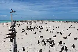
Michaelmas Cay is important as a breeding site for several species of terns. It has been identified by BirdLife International as an Important Bird Area (IBA) because it supports over 1% of the world populations of greater and lesser crested terns.[2] Sooty terns and common noddies also breed there. Other terns that have nested on the cay in the past include roseate and black-naped terns.[3]
Green turtles sometimes nest on the cays. The surrounding reefs have a rich marine fauna, including giant clams.[1]
See also
References
- 1 2 "Michaelmas and Upolu Cays National Park". National parks, marine parks and forests. Queensland Government. Retrieved 16 December 2014.
- ↑ "IBA: Michaelmas Cay". Birdata. Birds Australia. Archived from the original on 6 July 2011. Retrieved 15 August 2011.
- ↑ BirdLife International. (2011). Important Bird Areas factsheet: Michaelmas Cay. Downloaded from http://www.birdlife.org on 15 August 2011.