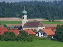
Michelsneukirchen | |
|---|---|
 Saint Michael Church | |
 Coat of arms | |
Location of Michelsneukirchen within Cham district  | |
 Michelsneukirchen  Michelsneukirchen | |
| Coordinates: 49°7′27″N 12°33′9″E / 49.12417°N 12.55250°E | |
| Country | Germany |
| State | Bavaria |
| Admin. region | Oberpfalz |
| District | Cham |
| Municipal assoc. | Falkenstein, Bavaria |
| Government | |
| • Mayor (2020–26) | Christian Raab[1] |
| Area | |
| • Total | 32.86 km2 (12.69 sq mi) |
| Elevation | 569 m (1,867 ft) |
| Population (2022-12-31)[2] | |
| • Total | 1,754 |
| • Density | 53/km2 (140/sq mi) |
| Time zone | UTC+01:00 (CET) |
| • Summer (DST) | UTC+02:00 (CEST) |
| Postal codes | 93185 |
| Dialling codes | 0 94 67 |
| Vehicle registration | CHA |
| Website | www |
Michelsneukirchen is a municipality in Oberpfälzer district of Cham in Bavaria in Germany.
Geography
The village is located in the Bavarian Forest. Adjoining municipalities are Schorndorf, Falkenstein, Obertrübenbach and in Zinzenzell in Niederbayern. There are several small villages in Michelsneukirchen, such as Dörfling, Woppmannsdorf, Momannsfelden, Regelsmais and Ponholz.
History
The village belonged to the masters of Falkenstein.
Crest
Michelsneukirchen's crest is "divided by red and gold; a silver flaming sword in front, three tilted lozenges in the back."
References
- ↑ Liste der ersten Bürgermeister/Oberbürgermeister in kreisangehörigen Gemeinden, Bayerisches Landesamt für Statistik, 15 July 2021.
- ↑ Genesis Online-Datenbank des Bayerischen Landesamtes für Statistik Tabelle 12411-003r Fortschreibung des Bevölkerungsstandes: Gemeinden, Stichtag (Einwohnerzahlen auf Grundlage des Zensus 2011)
External links
This article is issued from Wikipedia. The text is licensed under Creative Commons - Attribution - Sharealike. Additional terms may apply for the media files.