| Minhla Fortress | |
|---|---|
မင်းလှခံတပ် | |
| Minhla in Myanmar | |
 Minhla Fortress | |
| Coordinates | 19°58′15″N 95°02′37″E / 19.970791°N 95.043492°E |
| Type | Fortress |
| Site information | |
| Open to the public | Yes |
| Site history | |
| Built | 1860 |
| Fate | Mainly intact |
| Events | Third Anglo-Burmese War |
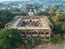
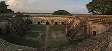
Minhla Fortress (Burmese: မင်းလှခံတပ်) is a historic fortress located in Minhla, Magway Region, Myanmar.
The fortress was built in 1860 to 1861 to defend the Konbaung dynasty's territory following the Second Anglo-Burmese War.[1] It was built with the assistance of French and Italian engineers, including Captain Molinari, an Italian engineer,[2] along the western bank of the Irrawaddy River.[1]
This fort, along with the Gwegyaung Fortress, was used as a defensive point of resistance by Burmese troops during the Third Anglo-Burmese War in 1885.[2]
See also
References
- 1 2 "A region with the Spirit Lake Mountain, woodcarving monasteries and ancient fortresses". The Myanmar Times. Retrieved 2018-10-15.
- 1 2 Report of the Superintendent. Archaeological Survey of Burma. 1902.
This article is issued from Wikipedia. The text is licensed under Creative Commons - Attribution - Sharealike. Additional terms may apply for the media files.