Molinaseca | |
|---|---|
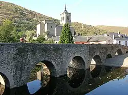
 Bridge over the Meruelo river, created in times of the Ancient Rome | |
 Coat of arms | |
 Molinaseca Location of Molinaseca in Spain | |
| Coordinates: 42°32′17″N 6°31′11″W / 42.53806°N 6.51972°W | |
| Country | |
| Autonomous community | |
| Province | |
| Region | |
| Municipality | Molinaseca |
| Government | |
| • Alcalde | Alfonso Arias Balboa (PP) |
| Area | |
| • Total | 79.63 km2 (30.75 sq mi) |
| Elevation | 580 m (1,900 ft) |
| Population (2018)[3] | |
| • Total | 872 |
| • Density | 11/km2 (28/sq mi) |
| Time zone | UTC+1 (CET) |
| • Summer (DST) | UTC+2 (CEST) |
| Area code | 987 |
| Climate | Csb |
| Website | www |
Molinaseca is a village and municipality located in the region of El Bierzo (province of León, Castile and León, Spain) . According to the 2010 census (INE), the municipality has a population of 818 inhabitants. It is located on the French Way, the most popular path of the Camino de Santiago.
Sister cities
References
- ↑ "Ficha de concejales" [Overview of Councillors] (XLS) (in Spanish). Ministry of Territorial Policy and Public Administrations. Retrieved June 1, 2012.
- ↑ "Territorio: Población, superficie y densidad por municipios" [Territory: Population, area and density by municipalities] (in Spanish). National Statistics Institute (INE). Archived from the original on March 14, 2012. Retrieved June 8, 2012.
- ↑ Municipal Register of Spain 2018. National Statistics Institute.
- ↑ Carro, María (August 1, 2011). "Molinaseca se hermana con una villa nipona" [Molinaseca becomes twinned with a Japanese village] (in Spanish). El Norte de Castilla. Retrieved June 1, 2012.
- ↑ "Lei nº 1633 de 26 de abril de 2012" [Law no. 1633 of April 7, 2012] (in Portuguese). Águas de São Pedro Municipal Council. Archived from the original (TIF) on May 23, 2014. Retrieved June 1, 2012.
42°32′N 6°31′W / 42.533°N 6.517°W
This article is issued from Wikipedia. The text is licensed under Creative Commons - Attribution - Sharealike. Additional terms may apply for the media files.
