Moncenisio | |
|---|---|
| Comune di Moncenisio | |
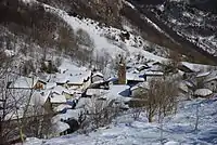 View of Moncenisio in winter | |
 Coat of arms | |
Location of Moncenisio | |
 Moncenisio Location of Moncenisio in Italy 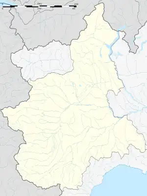 Moncenisio Moncenisio (Piedmont) | |
| Coordinates: 45°12′N 6°59′E / 45.200°N 6.983°E | |
| Country | Italy |
| Region | Piedmont |
| Metropolitan city | Turin (TO) |
| Government | |
| • Mayor | Bruno Perotto (Civic List) |
| Area | |
| • Total | 4.50 km2 (1.74 sq mi) |
| Elevation | 1,460 m (4,790 ft) |
| Population | |
| • Total | 30 |
| • Density | 6.7/km2 (17/sq mi) |
| Demonym | Moncenisino(i) or Ferrerese(i) |
| Time zone | UTC+1 (CET) |
| • Summer (DST) | UTC+2 (CEST) |
| Postal code | 10050 |
| Dialing code | 0122 |
| Patron saint | St. George |
| Saint day | Last Sunday in April |
| Website | Official website |
Moncenisio (Piedmontese: Monsnis, Arpitan: Moueini, French: Montcenis) is the smallest comune (municipality) in the Metropolitan City of Turin in the Italian region of Piedmont, located about 60 km west of Turin, on the border with France, in Val Cenischia.

Moncenisio
Moncenisio borders the following municipalities: Val-Cenis (France), Novalesa, and Venaus.
The village of Moncenisio
References
- ↑ "Superficie di Comuni Province e Regioni italiane al 9 ottobre 2011". Italian National Institute of Statistics. Retrieved 16 March 2019.
- ↑ All demographics and other statistics: Italian statistical institute Istat.
- ↑ "Popolazione Residente al 1° Gennaio 2018". Italian National Institute of Statistics. Retrieved 16 March 2019.
External links
This article is issued from Wikipedia. The text is licensed under Creative Commons - Attribution - Sharealike. Additional terms may apply for the media files.