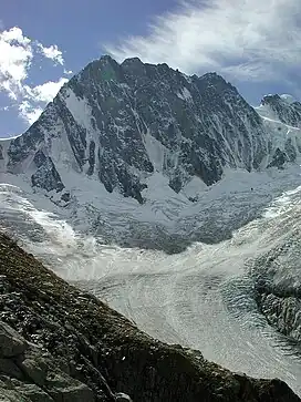
| Mont Mallet | |
|---|---|
 Mont Mallet France | |
| Highest point | |
| Elevation | 3,989 m (13,087 ft) |
| Coordinates | 45°51′55″N 06°57′38″E / 45.86528°N 6.96056°E |
| Geography | |
| Location | Haute-Savoie, France |
| Parent range | Mont Blanc Massif |
Mont Mallet (3,989 metres (13,087 ft)) is a mountain in the Mont Blanc massif in Haute-Savoie, France. It lies on a spur running northwards from the French-Italian frontier ridge, and can be most easily reached from the Aiguille de Rochefort.
Mont Mallet was first climbed on 4th September 1871. The first ascension party consisted of Leslie Stephen, Gabriel Loppé, F. Wallroth, Melchior Anderegg, Cachet and A. Tournier. They reached it via its southern ridge, a route now graded on the French adjectival climbing scale as PD. Its north ridge (graded AD) was first climbed in 1882.[1]
References
External links
This article is issued from Wikipedia. The text is licensed under Creative Commons - Attribution - Sharealike. Additional terms may apply for the media files.


