| Monte della Guardia | |
|---|---|
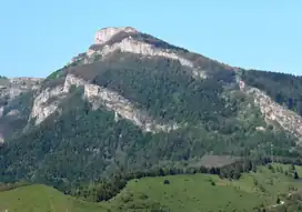
 View from Forte Pozzanghi (Colle di Nava) | |
| Highest point | |
| Elevation | 1,658 m (5,440 ft) |
| Prominence | 88[1] |
| Coordinates | 44°07′19″N 7°55′47″E / 44.12189°N 7.92965°E |
| Naming | |
| English translation | Mountain of the guard |
| Language of name | Italian |
| Geography | |
 Monte della Guardia Location in the Alps | |
| Location | Piedmont, Italy |
| Parent range | Ligurian Alps |
| Geology | |
| Age of rock | Triassic |
| Mountain type | limestone |
| Climbing | |
| First ascent | ancestral |
| Easiest route | hike from Colle di Caprauna |
The Monte della Guardia is a mountain in Piedmont, northern Italy, part of the Alps. At an altitude of 1,658 metres is one of the highest summits of the Ligurian Prealps.
Geography

The mountain stands on the main chain of the Alps between Tanaro and Arroscia valleys. It belongs to the province of Cuneo, in Piedmont, and is located on the border between the municipalities of Ormea and Caprauna, not faraway from Liguria.[2]
SOIUSA classification
According to the SOIUSA (International Standardized Mountain Subdivision of the Alps) the mountain can be classified in the following way:[3]
- main part = Western Alps
- major sector = South Western Alps
- section = Ligurian Alps
- subsection = Prealpi Liguri
- supergroup = Catena Settepani-Carmo-Armetta
- group = Gruppo Galero-Armetta
- subgroup = Costiera Galero-Armetta
- code = I/A-1.I-A.3.a
Geology
The area of Monte della Guardia is characterized by triassic limestone.[4] Towards monte Armetta, on the slopes facing the Tanaro valley, stands a large cave known as Grotta dei Dighè[5] or Garb del Dighea. It was surveyed at the end of the 19th century by entomologists that detected an interesting troglofauna with Plectogona sanfilippoi, subsp. Digheae, an arthropod endemic of Tanaro valley.[6][4]
Environment
The northern side of the mountain fells with overhanging cliffs towards the valley of Tanaro river, while its gentler southern slopes are mainly covered of woods.
Access to the summit
The summit can be easily reached with a short diversion from the Alta Via dei Monti Liguri, a long-distance trail from Ventimiglia (province of Imperia) to Bolano (province of La Spezia) which flancks the mountain on its Ligurian Sea side.[7] In wintertime the northern slopes of Monte della Guardia offer some interesting icefalls.[8]
References
- ↑ Key Col: Colla Bassa, 1570 m
- ↑ 1:25.000 map of Istituto Geografico Militare (IGM), on-line on www.pcn.minambiente.it
- ↑ Marazzi, Sergio (2005). Atlante Orografico delle Alpi. SOIUSA (in Italian). Priuli & Verlucca. ISBN 978-88-8068-273-8.
- 1 2 Bollettino del Club alpino italiano (in Italian). 1900. p. 86. Retrieved 2019-03-06.
- ↑ AA.VV. (1927). Le grotte d'Italia organo ufficiale dell'azienda autonoma di Stato delle R. Grotte demaniali di Postumia (in Italian). Mondaini. p. 116. Retrieved 5 June 2019.
- ↑ "Colle di Caprauna - Monte Armetta" (in Italian). Retrieved 2019-06-04.
- ↑ "Monte della Guardia (m. 1654), Monte Armetta (m. 1739), M. Dubasso (m. 1538) da Caprauna" (in Italian). Retrieved 2019-06-04.
- ↑ Sertori, Mario (2004). "Valle Tanaro". Cascatea (in Italian). BLU Edizioni. p. 69. ISBN 9788887417951. Retrieved 2019-06-04.
![]() Media related to Monte della Guardia at Wikimedia Commons
Media related to Monte della Guardia at Wikimedia Commons
