Monument, Kansas | |
|---|---|
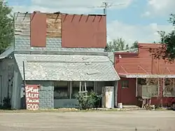 Buildings in Monument (2011) | |
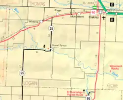 KDOT map of Logan County (legend) | |
 Monument  Monument | |
| Coordinates: 39°6′16″N 101°0′26″W / 39.10444°N 101.00722°W[1] | |
| Country | United States |
| State | Kansas |
| County | Logan |
| Elevation | 3,173 ft (967 m) |
| Population | |
| • Total | 56 |
| Time zone | UTC-6 (CST) |
| • Summer (DST) | UTC-5 (CDT) |
| Area code | 785 |
| FIPS code | 20-48025 [1] |
| GNIS ID | 471338 [1] |
Monument is an unincorporated community in northeast Logan County, Kansas, United States.[1] As of the 2020 census, the population of the community and nearby areas was 56.[2] It is located along U.S. Route 40 west of Oakley.
History
Established sometime in the latter half of the 19th century, it was originally called Monument Station as it served as a stop for the overland stage and for travelers moving westward through Fort Wallace.
Geography
Climate
According to the Köppen Climate Classification system, Monument has a semi-arid climate, abbreviated "BSk" on climate maps.[3]
Demographics
| Census | Pop. | Note | %± |
|---|---|---|---|
| 2020 | 56 | — | |
| U.S. Decennial Census | |||
For statistical purposes, the United States Census Bureau has defined this community as a census-designated place (CDP).
Transportation
U.S. Route 40 highway and Union Pacific Railroad pass through Monument.
References
- 1 2 3 4 5 "Monument, Kansas", Geographic Names Information System, United States Geological Survey, United States Department of the Interior
- 1 2 "Profile of Monument, Kansas (CDP) in 2020". United States Census Bureau. Archived from the original on November 17, 2021. Retrieved November 17, 2021.
- ↑ Climate Summary for Monument, Kansas
Further reading
External links
Municipalities and communities of Logan County, Kansas, United States | ||
|---|---|---|
| Cities | 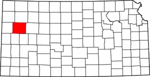 Map of Kansas highlighting Logan County | |
| Unincorporated communities | ||
| Ghost towns | ||
| Footnotes | †This community is designated a Census-Designated Place (CDP) by the United States Census Bureau. ‡This community also has portions in an adjacent county or counties. | |
This article is issued from Wikipedia. The text is licensed under Creative Commons - Attribution - Sharealike. Additional terms may apply for the media files.