| Morozumi Range | |
|---|---|
.jpg.webp) Processing an alluvial fan in the range, 20 January 2016 | |
| Highest point | |
| Elevation | 1,466 m (4,810 ft) |
| Geography | |
 | |
| Range coordinates | 71°39′S 161°55′E / 71.650°S 161.917°E |
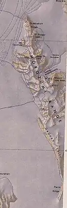
The Morozumi Range (71°39′S 161°55′E / 71.650°S 161.917°E) is a spectacular mountain range of unusual scenic beauty in the Usarp Mountains of North Victoria Land, Antarctica. It extends northwest–southeast for 25 miles (40 km), with its northern elevations overlooking the convergence of Gressitt Glacier and Rennick Glacier.
Early exploration and name
The Morozumi Range was mapped by the United States Geological Survey from surveys and United States Navy air photos in 1960–63. It was named by the Advisory Committee on Antarctic Names (US-ACAN) for Henry M. Morozumi, an aurora scientist at South Pole Station in 1960, and Station Scientific Leader at Byrd Station in 1963.[1]
Geology
The Morozumi Range is in the Rennick Graben, separated by the Rennick Faults from the Wilson Group rocks of the USARP mountains. Basement rocks are low-grade metasedimentary rocks that include greywacke-shale. The northern end holds the Adamellite Massif, a pluton of Granite Harbour Intrusives.[2]
Glaciers
Gressitt Glacier
71°30′S 161°15′E / 71.500°S 161.250°E. A broad glacier, about 45 mi long, draining the area between Daniels Range and Emlen Peaks in the Usarp Mountains and flowing northeast to enter the Rennick Glacier just north of the Morozumi Range. Mapped by USGS from surveys and U.S. Navy air photos, 1960–63. Named by US-ACAN for biologist J. Linsley Gressitt, Program Director who made biological studies, particularly in the Ross Sea area, in six austral summers, 1959-60 to 1965-66.[3]
Rennick Glacier
70°30′S 160°45′E / 70.500°S 160.750°E. A broad glacier, nearly 200 miles (320 km) long, which is one of the largest in Antarctica. It rises on the polar plateau westward of Mesa Range and is 20 to 30 miles (32 to 48 km) wide, narrowing to 10 miles (16 km) near the coast. It takes its name from Rennick Bay where the glacier reaches the sea.[4] The Rennick Glacier flows north between the east side of the Morozumi Range and the west side of the Lanterman Range.[5]
Features

Features from north to south are:[6]
Graduation Ridge
71°28′S 161°44′E / 71.467°S 161.733°E. A high rock ridge north of El Pulgar, forming the north extremity of Morozumi Range. Mapped by USGS from surveys and U.S. Navy air photos, 1960-63. The ridge was visited by NZGSAE, 1967–68, who gave the name because geologist J.A.S. Dow received his exam results here.[7]
El Pulgar
71°29′S 161°46′E / 71.483°S 161.767°E. A precipitous granite monolith, 1,660 metres (5,450 ft) high, standing 3 miles (4.8 km) north of Berg Peak in northern Morozumi Range. The feature was climbed by four members of NZGSAE, 1967-68, who gave the name El Pulgar (Spanish for "the thumb").[8]
Mount Twomey
71°30′S 161°41′E / 71.500°S 161.683°E. A somewhat detached peak over 120 metres (390 ft) high situated on the northwest margin of the Morozumi Range, 2.5 miles (4.0 km) northwest of Berg Peak. Mapped by USGS from surveys and U.S. Navy air photos, 1960-63. Named by US-ACAN for Arthur A. Twomey, USARP geologist at McMurdo Station, 1967-68 and 1968-69.[9]
Sickle Nunatak
71°32′S 161°57′E / 71.533°S 161.950°E. A nunatak at the north side of the entrance to Jupiter Valley, on the east side of the Morozumi Range. So named by members of the NZGSAE, 1967-68, because of its shape.[10]
Berg Peak
71°32′S 161°47′E / 71.533°S 161.783°E. A prominent peak, 1,870 metres (6,140 ft) high, standing 3 miles (4.8 km) south of El Pulgar in northern Morozumi Range. Mapped by USGS from surveys and U.S. Navy air photos, 1960–63. Named by US-ACAN for Thomas E. Berg, geologist who wintered at McMurdo Sound in 1961, and spent three succeeding summer seasons making patterned ground studies in the area. Berg perished in the crash of a U.S. Navy helicopter near Mount McLennan, Nov. 19, 1969.[11]
Jupiter Amphitheatre
71°34′S 161°51′E / 71.567°S 161.850°E. A steep-walled valley of great beauty in eastern Morozumi Range. The valley is occupied by a glacier and is entered between Sickle Nunatak and Mount Van Veen. Mapped by USGS from surveys and U.S. Navy air photos, 1960-63. The name was applied by the NZGSAE during the 1967-68 season.[12]
Mount Van Veen
71°35′S 161°54′E / 71.583°S 161.900°E. A precipitous, mainly ice-free mountain rising to 1,510 metres (4,950 ft) at the south side of Jupiter Amphitheatre in the Morozumi Range. Mapped by USGS from surveys and U.S. Navy air photos, 1960-63. Named by US-ACAN for Richard C. Van Veen, USARP geologist at McMurdo Station, 1967-68.[13]
DeGoes Cliff
.jpg.webp)
71°44′S 161°54′E / 71.733°S 161.900°E- A steep rock cliff on the west side of Morozumi Range. The cliff is over 6 miles (9.7 km) long. Its northern end is 6 miles (9.7 km) southwest of Mount Van Veen. Mapped by USGS from surveys and U.S. Navy air photos, 1960-63. Named by US-ACAN for Louis DeGoes of the National Academy of Sciences, Executive Secretary of the Committee on Polar Research, National Research Council.[14]
Paine Ridge
71°50′S 162°00′E / 71.833°S 162.000°E. A saber-shaped ridge largely composed of bare rock, extending southward from DeGoes Cliff at the SW end of the Morozumi Range. Mapped by USGS from surveys and U.S. Navy air photos, 1960-63. Named by US-ACAN for Roland D. Paine, Public Information Officer, National Science Foundation, who worked at McMurdo Station, 1960-61 and 1968-69.[15]
Nearby isolated features
Lonely One Nunatak
71°12′S 161°18′E / 71.200°S 161.300°E An eroded rock outcrop 16 miles (26 km) northwest of Morozumi Range. The low outcrop rises above the relatively featureless ice at the west side of the confluence of the Gressitt and Rennick Glaciers. The name applied by the northern party of NZGSAE, 1963–64, alludes to the relative isolation of the feature.[16]
Onlooker Nunatak
71°54′S 162°22′E / 71.900°S 162.367°E. An isolated nunatak which protrudes prominently above the ice of the Rennick Glacier just southeast of Morozumi Range. Named by the northern party of NZGSAE, 1963–64. The name is suggestive of the aspect of the feature.[17]
Renirie Rocks
71°20′S 161°20′E / 71.333°S 161.333°E. An elliptical rock outcrop 1.5 miles (2.4 km) long at the west side of the terminus of Gressitt Glacier, 10 miles (16 km) northwest of Morozumi Range. Mapped by USGS from surveys and U.S. Navy air photos, 1960–63. Named by US-ACAN for Jack Renirie, USARP Public Information Officer at McMurdo Station in at least five austral summer seasons, 1962-63 through 1970-71.[4]
Litell Rocks
71°24′S 162°00′E / 71.400°S 162.000°E. An area of rock outcrops within the lower Rennick Glacier, located 5 miles (8.0 km) east of the north end of Morozumi Range. Mapped by USGS from ground surveys and U.S. Navy air photos, 1960–62. Named by US-ACAN for Richard J. Litell, public information officer, National Science Foundation, who served in four summer seasons in Antarctica, 1960-64.[18]
References
- ↑ Alberts 1995, p. 505.
- ↑ Faure & Mensing 2010, p. 112.
- ↑ Alberts 1995, p. 295.
- 1 2 Alberts 1995, p. 613.
- ↑ Mount Soza USGS.
- ↑ Daniels Range USGS.
- ↑ Alberts 1995, p. 290.
- ↑ Alberts 1995, p. 219.
- ↑ Alberts 1995, p. 768.
- ↑ Alberts 1995, p. 674.
- ↑ Alberts 1995, p. 61.
- ↑ Alberts 1995, p. 379.
- ↑ Alberts 1995, p. 777.
- ↑ Alberts 1995, p. 180.
- ↑ Alberts 1995, p. 553.
- ↑ Alberts 1995, p. 441.
- ↑ Alberts 1995, p. 545.
- ↑ Alberts 1995, p. 437.
Sources
- Alberts, Fred G., ed. (1995), Geographic Names of the Antarctic (PDF) (2 ed.), United States Board on Geographic Names, retrieved 2023-12-03
 This article incorporates public domain material from websites or documents of the United States Board on Geographic Names.
 - USGS United States Geological Survey (1968), Daniels Range, retrieved 2023-12-14
- Faure, Gunter; Mensing, Teresa M. (2010), The Transantarctic Mountains: Rocks, Ice, Meteorites and Water, Springer Science & Business Media, ISBN 9789048193905, retrieved 2023-12-14
- USGS United States Geological Survey (1967), Mount Soza, retrieved 2023-12-14
Further reading
- Allen, Boyd III; Mayewski, Paul Andrew; Lyons, W. Berry; and Spencer, Mary Jo, Glaciochemical Studies and Estimated Net Mass Balances for Rennick Glacier Area, Antarctica, (1985). Earth Science Faculty Scholarship. 203 https://digitalcommons.library.umaine.edu/ers_facpub/203
- A B Pour, Y Park, M Hashim, and J K Hong, Regional geological mapping in Northern Victoria Land, Antarctica using multispectral remote sensing satellite data, IOP Conf. Series: Earth and Environmental Science 169 (2018) 012081 doi :10.1088/1755-1315/169/1/012081
- R. L. Oliver, P. R. James, J. B. Jago, Antarctic Earth Science, P 141
- Amin Beiranvand Pour, Yongcheol Park, Jong Kuk Hong and Mazlan Hashim, MAPPING GONDWANA-DERIVED TERRANE USING REMOTE SENSING SATELLITE DATA IN ANTARCTICA