| Mount Abbl | |
|---|---|
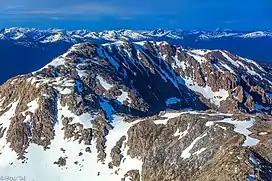
 Looking S across Mount Abbl toward Monkman Park | |
| Highest point | |
| Elevation | 2,012 m (6,601 ft) |
| Prominence | 654 m (2,146 ft)[1] |
| Parent peak | Scatia Peak (2383 m)[1] |
| Listing | Mountains of British Columbia |
| Coordinates | 54°41′02″N 121°42′33″W / 54.68389°N 121.70917°W[2] |
| Geography | |
 Mount Abbl  Mount Abbl | |
| Country | Canada |
| Province | British Columbia |
| District | Cariboo Land District[3] |
| Parent range | Misinchinka Ranges |
| Topo map | NTS 93I12 Missinka River[2] |
Mount Abbl is a 2,012-metre (6,601 ft) mountain in the Miscinchinka Ranges of the Hart Ranges in the Northern Rocky Mountains.[4]
Named for Canadian Army Private Ernest E. Abbl, from Prince George, BC. Private Abbl served with the 2nd Canadian Division, 5th Infantry Brigade, Calgary Highlanders and was killed in action 8 February 1945, age 19 in the opening days of Operation Veritable. He is buried at Groesbeek Canadian War Cemetery, Netherlands, grave V.A.14.[3]
References
- 1 2 "Mount Abbl". Bivouac.com. Retrieved 2023-10-19.
- 1 2 "Mount Abbl". Geographical Names Data Base. Natural Resources Canada. Retrieved 19 October 2023.
- 1 2 "Mount Abbl". BC Geographical Names. Retrieved 28 May 2020.
- ↑ "Mount Abbl". PeakVisor.com. Retrieved 28 May 2020.
This article is issued from Wikipedia. The text is licensed under Creative Commons - Attribution - Sharealike. Additional terms may apply for the media files.