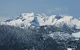
| Mount Clarke | |
|---|---|
 South aspect | |
| Highest point | |
| Elevation | 2,159 m (7,083 ft) |
| Prominence | 689 m (2,260 ft) |
| Coordinates | 49°31′59.0″N 122°06′10.0″W / 49.533056°N 122.102778°W |
| Geography | |
| Location | British Columbia, Canada |
| District | New Westminster Land District |
| Parent range | Pacific Ranges |
| Topo map | NTS 92G9 Stave River |
| Climbing | |
| First ascent | 1949 Lan Kay; A. Melville; F. Miles; Howard Rode |
Mount Clarke is a mountain in southwestern British Columbia, Canada, located 21 km (13 mi) northwest of Hemlock Valley and 6 km (4 mi) south of Grainger Peak. It is part of the Douglas Ranges, the southernmost subdivision of the Pacific Ranges which in turn form part of the Coast Mountains.[1]
The northwest ridge of Mount Clarke contains the sub-peaks Viennese and Recourse, which are considered separate peaks.[1]
References
- 1 2 Mount Clarke in the Canadian Mountain Encyclopedia
This article is issued from Wikipedia. The text is licensed under Creative Commons - Attribution - Sharealike. Additional terms may apply for the media files.