Mount Hochlin
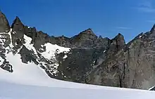
Mount Hochlin (72°5′S 4°3′E / 72.083°S 4.050°E) is a large ice-topped mountain, 2,760 metres (9,060 ft) high, standing east of Festninga Mountain in the Mühlig-Hofmann Mountains of Queen Maud Land, Antarctica. The Spøta Spur extends from its north-central section. It was mapped by Norwegian cartographers from surveys and air photos by the Sixth Norwegian Antarctic Expedition (1956–60) and named for L. Hochlin, a radio operator and dog driver with the expedition (1956–58).[1]
See also
References
![]() This article incorporates public domain material from "Hochlin, Mount". Geographic Names Information System. United States Geological Survey.
This article incorporates public domain material from "Hochlin, Mount". Geographic Names Information System. United States Geological Survey.
This article is issued from Wikipedia. The text is licensed under Creative Commons - Attribution - Sharealike. Additional terms may apply for the media files.