| Mount Yoko | |
|---|---|
| 横岳 | |
 | |
| Highest point | |
| Elevation | 2,480 m (8,140 ft) |
| Prominence | 400 m (1,300 ft) |
| Listing | List of mountains and hills of Japan by height |
| Coordinates | 36°5′15″N 138°19′12″E / 36.08750°N 138.32000°E |
| Geography | |
| Location | Honshū, Japan |
| Parent range | Northern Yatsugatake Volcanic Group |
| Topo map | Geographical Survey Institute 25000:1 蓼科山, 25000:1 蓼科, 50000:1 蓼科山 |
| Geology | |
| Age of rock | Quaternary |
| Mountain type | Volcanic |
| Volcanic arc/belt | Northeastern Japan Arc |
| Last eruption | 1200 ±100 years |
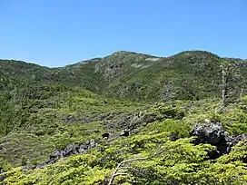
Mount Yoko (横岳, Yoko-dake) also Mount Kita Yoko, is an active lava dome located in the Northern Yatsugatake Volcanic Group of the Yatsugatake Mountains, Honshū, Japan. Mount Yoko has shown the most recent activity and is now considered an active volcano. It last erupted about 800 years ago.[1] The eruption consisted of ash with a lava flow of some 3 million cubic meters. The eruption was dated by corrected radiocarbon dating. The next previous eruption was in or after 400 BCE.[2]
References
- ↑ "KITA YATSU-GA-TAKE (TATESHINA-YAMA, YOKO-DAKE etc.)". Quaternary Volcanoes of Japan. Geological Survey of Japan, AIST. 2006. Archived from the original on 2012-12-19. Retrieved 2008-08-23.
- ↑ "Yokodake". Global Volcanism Program. Smithsonian Institution. Retrieved 2021-06-24.
This article is issued from Wikipedia. The text is licensed under Creative Commons - Attribution - Sharealike. Additional terms may apply for the media files.