| Town of Claremont Western Australia | |||||||||||||||
|---|---|---|---|---|---|---|---|---|---|---|---|---|---|---|---|
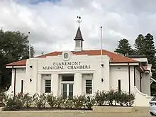
 Town of Claremont offices | |||||||||||||||
| Population | 11,284 (LGA 2021)[1] | ||||||||||||||
| Established | 1898 | ||||||||||||||
| Area | 4.9 km2 (1.9 sq mi) | ||||||||||||||
| Mayor | Jock Barker | ||||||||||||||
| Council seat | Claremont | ||||||||||||||
| Region | West Metropolitan Perth | ||||||||||||||
| State electorate(s) | Nedlands, Cottesloe | ||||||||||||||
| Federal division(s) | Curtin | ||||||||||||||
 | |||||||||||||||
| Website | Town of Claremont | ||||||||||||||
| |||||||||||||||
The Town of Claremont is a local government area in the inner western suburbs of the Western Australian capital city of Perth, located about halfway between the port city of Fremantle and Perth's central business district. The Town covers an area of 4.9 square kilometres (1.9 sq mi), maintains 48 km of roads and 87 km of footpaths, and has a population of approximately 10,000 as at the 2016 Census.
History
The Municipality of Claremont was created on 17 June 1898 out of parts of the Claremont Road District. On 1 July 1961, Claremont became a town following the enactment of the Local Government Act 1960.[2]
Wards
The Town is divided into 3 wards, each electing three councillors. The mayor is directly elected.
- South Ward
- West Ward
- East Ward
Suburbs
The suburbs of the Town of Claremont with population and size figures based on the most recent Australian census:[3][4]
| Suburb | Population | Area | Map |
|---|---|---|---|
| Claremont * | 9,248 (SAL 2021)[5] | 4 km2 (1.5 sq mi) | |
| Swanbourne * | 4,592 (SAL 2021)[6] | 5.2 km2 (2.0 sq mi) |
Landmarks
The Claremont Showground is home each year to the annual Perth Royal Show in September–October. Claremont railway station is located adjacent to the Town's main shopping area, which consists of cafes and street shopping in Bay View Terrace and St Quentin's Avenue, as well as the Claremont Quarter shopping centre. Claremont Oval is used for Australian Rules football, and there is a par-three golf course at Lake Claremont. Other landmarks include several private schools: Scotch College, Methodist Ladies' College and Christ Church Grammar School.
On 18 November 2010 the heritage listed Council Chambers were gutted by fire. The fire which started in the local library at the rear of the buildings spread through the offices and chambers, causing millions of dollars worth of damage.[7][8][9]
Population
|
|
Mayors
Heritage listed places
As of 2023, 854 places are heritage-listed in the Town of Claremont,[10] of which 20 are on the State Register of Heritage Places, among them the Claremont Teachers College, the Claremont Post Office and the Claremont Railway Station.[11]
See also
- AmpFest, Youth and music festival overseen by the Town of Claremont
References
- ↑ Australian Bureau of Statistics (28 June 2022). "Claremont (Local Government Area)". Australian Census 2021 QuickStats. Retrieved 28 June 2022.
- ↑ "Municipality Boundary Amendments Register" (PDF). Western Australian Electoral Distribution Commission. Retrieved 11 January 2020.
- ↑ "SLIP Map". maps.slip.wa.gov.au. Landgate. Retrieved 1 January 2023.
- ↑ "NationalMap". nationalmap.gov.au. Geoscience Australia. Retrieved 1 January 2023.
- ↑ Australian Bureau of Statistics (28 June 2022). "Claremont (WA) (suburb and locality)". Australian Census 2021 QuickStats. Retrieved 28 June 2022.
- ↑ Australian Bureau of Statistics (28 June 2022). "Swanbourne (suburb and locality)". Australian Census 2021 QuickStats. Retrieved 28 June 2022.
- ↑ "Fire destroys Claremont Council offices". PerthNow. The Sunday Times. 19 November 2010. Retrieved 19 November 2010.
- ↑ "Fire guts Claremont council and library". 720 ABC Perth. ABC Radio. 19 November 2010. Retrieved 19 November 2010.
- ↑ Thomas, Beatrice (19 November 2010). "Fire destroys Claremont council offices". The West Australian. Retrieved 19 November 2010.
- ↑ "Town of Claremont Heritage Places". inherit.stateheritage.wa.gov.au. Heritage Council of Western Australia. Retrieved 19 February 2023.
- ↑ "Town of Claremont State Register of Heritage Places". inherit.stateheritage.wa.gov.au. Heritage Council of Western Australia. Retrieved 19 February 2023.