Județul Năsăud | |
|---|---|
County (Județ) | |
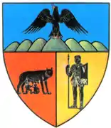
 Coat of arms | |
 | |
| Country | |
| Historic region | Transylvania |
| Capital city (Reședință de județ) | Bistrița |
| Established | 1925 |
| Ceased to exist | Administrative reform of 1950 |
| Area | |
| • Total | 4,326 km2 (1,670 sq mi) |
| Population (1930) | |
| • Total | 144,131 |
| • Density | 33/km2 (86/sq mi) |
| Time zone | UTC+2 (EET) |
| • Summer (DST) | UTC+3 (EEST) |
Năsăud County is one of the historic counties of Transylvania, Romania. The county seat was Bistrița.[1]
Geography
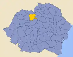
Năsăud County was located in the north-central part of Greater Romania, in the north of Transylvania, covering 4,326 km2 (1,670 sq mi).[1] Currently, the territory that comprised Năsăud County is mostly included in the Bistrița-Năsăud County, while its eastern part belongs now to Suceava County.
In the interwar period, the county was bordered on the south by Mureș County and a small part of Cluj County, to the west by Someș County, to the north by Maramureș County, and to the east by the counties of Câmpulung and Neamț.[1]
History
The territory of Năsăud County was ceded to Romania by Hungary, as successor state to Austria-Hungary in the Treaty of Trianon (1920). Prior to then, the territory formed Beszterce-Naszód County in the Kingdom of Hungary. Romanian authorities established the county in 1925.
In 1938, the county was disestablished and incorporated into the newly formed Ținutul Mureș.[2] In September 1940, following the Second Vienna Award, the county was annexed by Hungary and incorporated into a re-formed Beszterce-Naszód County until 1944. In 1945, the county was re-established under Romanian rule and it was abolished in 1950 by the Communist regime,[2] becoming part of the Rodna Region.
Administrative organization

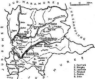
Administratively, Năsăud County was originally divided into four districts (plăși):[1]
- Plasa Bârgău
- Plasa Năsăud
- Plasa Rodna
- Plasa Șieu
Subsequently, the number of districts in the county became six, by setting up two new districts:
- Plasa Centrală
- Plasa Lechința
Population
According to the 1930 census data, the county population was 144,131, ethnically divided as follows: 71.5% Romanians, 14.4% Germans, 5.2% Hungarians, 4.4% Jews, 4.1% Romanies, as well as other minorities. Categorized by mother tongue, the population spoke Romanian (73.9%), German (14.6%), Hungarian (5.0%), Yiddish (4.1%), as well as other minority languages.[3] From the religious point of view, the population was 60.2% Greek Catholic, 15.5% Lutheran, 13.8% Eastern Orthodox, 4.4% Jewish, 3.6% Reformed, 2.3% Roman Catholic, as well as other minorities.[4]
Urban population
In 1930, the county's urban population was 17,640, ethnically divided as follows: 48.4% Romanians, 25.8% Germans, 14.7% Jews, 8.3% Hungarians, as well as other minorities. Categorized by mother tongue, the population spoke Romanian (48.5%), German (26.9%), Yiddish (13.9%), Hungarian (9.0%), as well as other minority languages. From the religious point of view, the urban population was composed of 38.7% Greek Catholic, 23.8% Lutheran, 14.9% Jewish, 10.4% Eastern Orthodox, 6.5% Roman Catholic, 5.3% Reformed, as well as other minorities.
References
- 1 2 3 4 "Portretul României interbelice – Județul Năsăud" (in Romanian). memoria.ro. Retrieved 17 August 2016.
- 1 2 "Organizarea administrativ-teritorială a României 1864–1989" (in Romanian). bzf.ro. 7 May 2013. Archived from the original on 29 September 2014. Retrieved 17 August 2016.
- ↑ Recensământul general al populației României din 29 decemvrie 1930, Vol. II, pag. 304-307
- ↑ Recensământul general al populației României din 29 decemvrie 1930, Vol. II, pag. 673-674
External links
- (in Romanian) Năsăud County on memoria.ro
