Nakhon Si Thammarat
จังหวัดนครศรีธรรมราช | |
|---|---|
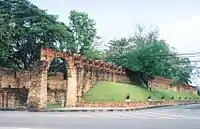
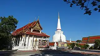
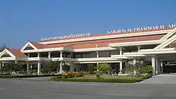
From left to right, top to bottom : Nakhon Si Thammarat City Wall, Wat Phra Mahathat, Nakhon Si Thammarat PAO Stadium, Nakhon Si Thammarat Airport, Nakhon Si Thammarat railway station | |
 Flag 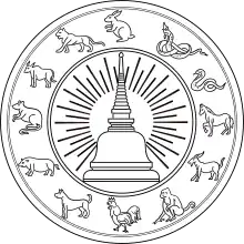 Seal | |
| Nickname: Mueang Khon (Thai: เมืองคอน) | |
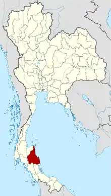 Map of Thailand highlighting Nakhon Si Thammarat province | |
| Coordinates: 8°25′7″N 99°57′49″E / 8.41861°N 99.96361°E | |
| Country | Thailand |
| Capital | Nakhon Si Thammarat |
| Government | |
| • Governor | Aphinan Phuekphong (since October 2022)[1] |
| Area | |
| • Total | 9,943 km2 (3,839 sq mi) |
| • Rank | Ranked 18th |
| Population (2018)[3] | |
| • Total | 1,560,433 |
| • Rank | Ranked 8th |
| • Density | 157/km2 (410/sq mi) |
| • Rank | Ranked 26th |
| Human Achievement Index | |
| • HAI (2017) | 0.5687 "Somewhat low" Ranked 55th |
| GDP | |
| • Total | baht 154 billion (US$5.3 billion) (2019) |
| Time zone | UTC+7 (ICT) |
| Postal code | 80xxx |
| Calling code | 075 |
| ISO 3166 code | TH-80 |
| Website | www |
Nakhon Si Thammarat province (Thai: จังหวัดนครศรีธรรมราช, pronounced [ná(ʔ).kʰɔ̄ːn sǐː tʰām.mā.râːt]) is a province (changwat) of Thailand, on the western shore of the Gulf of Thailand. As of 2018, it was the most populous province of Southern Thailand, with a population of approximately 1.5 million.[3] Neighboring provinces are (from south clockwise) Songkhla, Phatthalung, Trang, Krabi and Surat Thani.[6]
Names
Nakhon Si Thammarat is the Thai form of Sanskrit Nagara Sri Dharmaraja, meaning 'City of the Sacred Dharma King'. The name is sometimes abbreviated to Nakhon Si (Thai: ยครศรีฯ). The province is also colloquially called Mueang Khon (Thai: เมืองคอน) and its people Khon Khon (Thai: คนคอน).
Geography
The province is on the Gulf of Thailand on the east side of the Malay Peninsula. The terrain is mostly rugged hilly forest. The province is home to south Thailand's highest peak, Khao Luang, at 1,835 metres (6,000 ft).The total forest area is 1,820 km2 (700 sq mi) or 18.4 percent of provincial area.[7]
National parks
There area a total of six national parks, five of which, along with fifteen other national parks, make up region 5 (Nakhon Si Thammarat) and Khao Pu–Khao Ya in region 6 (Songkhla) of Thailand's protected areas.
- Khao Pu–Khao Ya National Park, 694 km2 (268 sq mi)[8]: 42
- Khao Luang National Park, 570 km2 (220 sq mi)[8]: 9
- Khao Nan National Park, 410 km2 (160 sq mi)[8]: 113
- Hat Khanom–Mu Ko Thale Tai National Park, 312 km2 (120 sq mi)[9]: 16
- Namtok Yong National Park, 205 km2 (79 sq mi)[8]: 64
- Namtok Si Khit National Park, 145 km2 (56 sq mi)[8]: 95
History
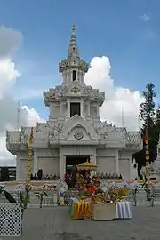
Nakhon Si Thammarat is one of the oldest cities in Thailand with a rich history. The earliest settlement in the vicinity of the city was Tha Rua, about ten kilometers south of the modern city, where ceramics from the Song dynasty were found dated to the twelfth century. In ancient times, Nakhon Si Thammarat was under the rule of the Srivijaya, the king of Srivijaya had established a foothold on the Malay Peninsula at Ligor" by 775, where he "built various edifices, including a sanctuary dedicated to the Buddha and to the Bodhisattvas Padmapani and Vajrapani.
The Chronicles of Nakhon Si Thammarat, composed in the seventeenth century, attributed the foundation of current city of Nakhon Si Thammarat to King Sri Thammasok in the thirteenth century. An inscription found at Chaiya stated that King Sri Thammasok ruled Tambralinga in 1231. King Sri Thammasok constructed Wat Phra Mahathat and introduced Singhalese Theravada Buddhism. The Nakhon Si Thammarat Kingdom held authorities over "twelve cities" that extended from Chumphon to the north and Pahang to the south. The Ramkamhaeng Stele of Sukhothai first mentioned "Nakhon Si Thammarat" in 1292, which means "The City of King Sri Thammasok" or "The City of the Virtuous king". The Nakhon Si Thammarat kingdom ended and the city perished in the fourteenth century. The ruler of Phetchaburi known as Phra Phanom Thale sent his son Phra Phanom Wang to re-establish the city and rule. Nakhon Si Thammarat then came under the influence of Central Siamese Kingdom of Ayutthaya under the mandala system.
Ayutthaya Period
Nakhon Si Thammarat was further incorporated into Ayutthaya, who appointed governors to the city, through centralization under King Trailokanat in the fifteenth century. Nakhon Si Thammarat served as the main seat of Siamese authority over Southern Thailand and the Malay Peninsula, becoming Muang Ek or first-level city. Yamada Nagamasa, the Japanese adventurer, was appointed as the governor of Nakhon Si Thammarat in 1629.
After the Siamese revolution of 1688, the governor of Nakhon Si Thammarat rebelled against the new King Phetracha. King Phetracha sent troops to put down rebels in Nakhon Si Thammarat in 1692.
Thonburi Period
After the Fall of Ayutthaya in 1767, Phra Palat Nu the vice-governor of Nakhon Si Thammarat established himself as the local warlord and ruler over Southern Thailand. King Taksin of Thonburi marched south to subjugate Phra Palat Nu or Chao Phraya Nakhon Nu in 1769. Chao Phraya Nakhon Nu was taken to Thonburi but King Taksin re-installed Nakhon Nu as a tributary ruler of Nakhon Si Thammarat in 1776.
Rattanakosin Period
After Chaophraya Nakhon (Noi), his son and grandson became respective governors of Nakhon Si Thammarat. During the reforms of King Chulalongkorn, the traditional governorship of Nakhon Si Thammarat was abolished and the city was incorporated into the Monthon Nakhon Si Thammarat in 1896.
When the monthon system was abolished in 1932, Nakhon Si Thammarat then became a province until the present.
Environment
Forested peat swamp forests cover more than 9,900 hectares on the borders of Nakhon Si Thammarat, Phatthalung, and Songkhla provinces. About 800 hectares of the peat swamp were destroyed by 88 fires in the first half of 2019. The Royal Forest Department says that most of the fires in the Khuan Khreng peat swamp forest were man-made. Criminals clear the forest for the illegal expansion of rubber and oil palm plantations. Honey collectors and fishermen were also complicit as they burn grass to catch fish or to collect wild honey. Khuan Khreng peat swamp was hit by drought in what is normally the rainy season making it susceptible to arson. The forest is surrounded by oil palm plantations and surface water in the forest has been drained out to feed the plantations.[10]
The province is home to Khao Luang National Park and Hat Khanom–Mu Ko Thale Tai National Park.
Economy
Tourism has become a first-tier tourist province, as defined by the central government, joining 22 other first-tier provinces. In 2019, it is projected to receive four million tourists—80% of them domestic—largely attracted by religious sites. They contributed more than 11 billion baht to the provincial economy. The Airports Department plans to expand Nakhon Si Thammarat airport runways and terminal by 2022 to deal with an anticipated increase in international flights to support foreign visitor arrivals. The province has 320 hotels with 8,800 rooms, up from 310 hotels and 7,000 rooms in 2018.[11]
Symbols
The provincial seal shows the Phra Baromathat chedi of Wat Phra Mahathat Voramahavihan, one of the most important historical sites in southern Thailand. According to the city chronicle it was already built in 311, but archaeology dates it to the 13th century. The chedi was built by the ruler of Malay Buddha Kingdom of Tambralinga, named Chandrabhanu Sridhamaraja of The Patama Vamsa (Lotus Dynasty). The chedi is surrounded by the animals of the Chinese zodiac in the seal. The twelve animals represent the twelve Naksat cities or city-states which were tributary to the Nakhon Si Thammarat kingdom: the Rat of Saiburi; the Ox of Pattani; the Tiger of Kelantan; the Rabbit of Pahang (actually a city in Pahang which is said to be submerged by a lake now); the Dragon of Kedah; the Snake of Phatthalung; the Horse of Trang; the Goat of Chumphon; the Monkey of Bantaysamer (might be Chaiya, or a town in Krabi province); the Rooster of Sa-ulau (unidentified city, might be Songkhla, Kanchanadit or Pla Tha); the Dog of Takua Pa and a Pig of Kraburi.[12]
The provincial flower is the Golden Shower Tree (Cassia fistula), and the provincial tree is Millettia atropurpurea.[13]
The provincial slogan is เมืองประวัติศาสตร์ พระธาตุทองคำ ชื่นฉ่ำธรรมชาติ แร่ธาตุอุดม เครื่องถมสามกษัตริย์ มากวัดมากศิลป์ ครบสิ้นกุ้งปู, which translates to "A historical town, the golden Phra That, plentiful minerals, three-metal nielloware, numerous temples, abundant shellfish."[13]
Administrative divisions
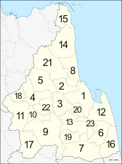
Provincial government
Nakhon Si Thammarat is divided into 23 districts (amphoes). The districts are further divided into 165 subdistricts (tambons) and 1428 villages (mubans).
Local government
As of 26 November 2019, there are:[14] one Nakhon Si Thammarat Provincial Administration Organisation (ongkan borihan suan changwat) and 54 municipal (thesaban) areas in the province. Nakhon Si Thammarat has (thesaban nakhon) status. Pak Phun, Thung Son and Pak Panang have town (thesaban mueang) status. Further 50 subdistrict municipalities (thesaban tambon). The non-municipal areas are administered by 130 Subdistrict Administrative Organisations - SAO (ongkan borihan suan tambon).[3]
Transport
Nakhon Si Thammarat is served by Nakhon Si Thammarat Airport and the Nakhon Si Thammarat Railway Station.
Health
Maharaj Nakhon Si Thammarat Hospital is the main hospital of the province, operated by the Ministry of Public Health.
Education
Universities
Public universities
- Walailak University[15]
- Nakhon Si Thammarat Rajabhat University
- Rajamangala University of Technology Srivijaya
- College of Industrial Technology and Management
- Nakhon Si Thammarat Saiyai Campus
- Nakhon Si Thammarat Thungyai Campus
- Thaksin University
- Management for Development College, Nakhon Si Thammarat Education Center
- Mahachulalongkornrajavidyalaya University, Nakhon Si Thammarat Campus
- Mahamakut Buddhist University, Sithammasokkarat Campus
- Ramkhamhaeng University, Nakhon Si Thammarat Regional Campus in Honour of His Majesty the King
- Sukhothai Thammathirat Open University, Nakhon Si Thammarat Regional Distance Education Center
- Boromarajonani College of Nursing Nakhon Si Thammarat
Vocational colleges
Public vocational colleges
- Nakhon Si Thammarat Technical College
- Thung Song Technical College
- Sichon Technical College
- Nakhon Si Thammarat Seaboard Industrial College
- Nakhon Si Thammarat Polytechnic College
- Nakhon Si Thammarat Vocational College
- Nakhon Si Thammarat Arts and Crafts College
- Nakhon Si Thammarat College of Agriculture and Technology
- Nakhon Si Thammarat Industrial and Community Education College
- Hua Sai Industrial and Community Education College
- Phrom Khiri Industrial and Community Education College
- Nakhon Si Thammarat Colleges of Dramatic Arts
- Nakhon Si Thammarat College of Fine Arts
Private vocational colleges
- Innovation Technological College
- Jaruspichakorn College of Technology
- Satapat Nakhon Technological College
- Thurakit Bundit Technological College
- Nakhon Commercial Vocational College
- Prateesasana Business Administration College
- Thaksin Vocational Technological College
- Pakphanang Vocational College
- Southern Technological College
- Thungsong Commercial College
- Charoenmit Commercial Technological College
- Sichon Commercial Technological College
- Virasinpin Vocational College
- Sakdisilpin Commercial School
Human achievement index 2017
| Health | Education | Employment | Income |
| 23 | 24 | 65 | 33 |
| Housing | Family | Transport | Participation |
 |
 |
 |
|
| 46 | 61 | 39 | 66 |
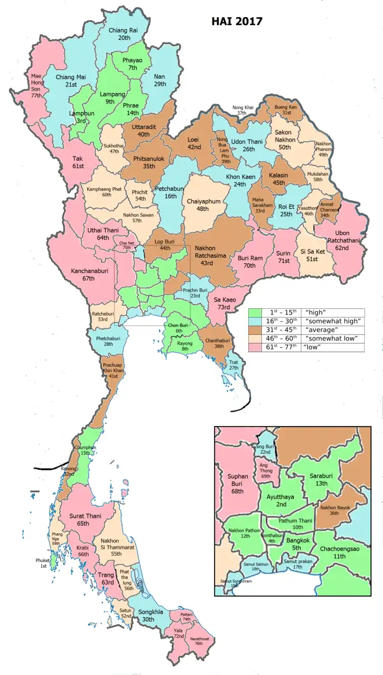
| Province Nakhon Si Thammarat, with an HAI 2017 value of 0.5687 is "somewhat low", occupies place 55 in the ranking. | |||
Nakhon Si Thammarat scored 55 ("somewhat low") on the United Nations Development Programme (UNDP) Human achievement index (HAI).[4]
| Rank | Classification |
| 1 - 15 | "high" |
| 16 - 30 | "somewhat high" |
| 31 - 45 | "average" |
| 45 - 60 | "somewhat low" |
| 61 - 77 | "low" |
| Map with provinces and HAI 2017 rankings |
 |
Sports
Football
Volleyball clubs
| Men's Volleyball Club | ||||||||||||||||||||||||||||||||||
|---|---|---|---|---|---|---|---|---|---|---|---|---|---|---|---|---|---|---|---|---|---|---|---|---|---|---|---|---|---|---|---|---|---|---|
| Team | Leagues | Level | Years | Region | Position | |||||||||||||||||||||||||||||
| Supreme Nakhon Si Thammarat | Men's Volleyball Thailand League | Level 1 | 2010–11 | Thailand | 8th | |||||||||||||||||||||||||||||
| Women's Volleyball Club | ||||||||||||||||||||||||||||||||||
| Team | Leagues | Level | Years | Region | Position | |||||||||||||||||||||||||||||
| Supreme Nakhon Si Thammarat | Women's Volleyball Thailand League | Level 1 | 2010–11 | Thailand | 5th | |||||||||||||||||||||||||||||
| 2011–12 | Thailand | 2nd | ||||||||||||||||||||||||||||||||
| 2012–13 | Thailand | 5th | ||||||||||||||||||||||||||||||||
See also
References
- ↑ "ประกาศสำนักนายกรัฐมนตรี เรื่อง แต่งตั้งข้าราชการพลเรือนสามัญ" [Announcement of the Prime Minister's Office regarding the appointment of civil servants] (PDF). Royal Thai Government Gazette. 139 (Special 227 Ngor). 2. 26 September 2022. Retrieved 25 June 2023.
- ↑ Advancing Human Development through the ASEAN Community, Thailand Human Development Report 2014, table 0:Basic Data (PDF) (Report). United Nations Development Programme (UNDP) Thailand. pp. 134–135. ISBN 978-974-680-368-7. Retrieved 17 January 2016, Data has been supplied by Land Development Department, Ministry of Agriculture and Cooperatives, at Wayback Machine.
{{cite report}}: CS1 maint: postscript (link) - 1 2 3 "รายงานสถิติจำนวนประชากรและบ้านประจำปี พ.ศ.2561" [Statistics, population and house statistics for the year 2018]. Registration Office Department of the Interior, Ministry of the Interior (in Thai). 31 December 2018. Retrieved 20 June 2019.
- 1 2 Human achievement index 2017 by National Economic and Social Development Board (NESDB), pages 1-40, maps 1-9, retrieved 14 September 2019, ISBN 978-974-9769-33-1
- ↑ "Gross Regional and Provincial Product, 2019 Edition". <>. Office of the National Economic and Social Development Council (NESDC). July 2019. ISSN 1686-0799. Retrieved 22 January 2020.
- ↑ "About Nakhon Si Thammarat". Tourism Authority of Thailand (TAT). Retrieved 2 August 2019.
- ↑ "ตารางที่ 2 พี้นที่ป่าไม้ แยกรายจังหวัด พ.ศ.2562" [Table 2 Forest area Separate province year 2019]. Royal Forest Department (in Thai). 2019. Retrieved 6 April 2021, information, Forest statistics Year 2019
{{cite web}}: CS1 maint: postscript (link) - 1 2 3 4 5 "ข้อมูลพื้นที่อุทยานแห่งชาติ ที่ประกาศในราชกิจจานุบกษา 133 แห่ง" [National Park Area Information published in the 133 Government Gazettes]. Department of National Parks, Wildlife and Plant Conservation (in Thai). December 2020. Retrieved 1 November 2022.
- ↑ "ข้อมูลพื้นที่อุทยานแห่งชาติ (เตรียมการ) 22 แห่ง" [Information of 22 National Parks Areas (Preparation)]. Department of National Parks, Wildlife and Plant Conservation (in Thai). December 2020. Retrieved 1 November 2022.
- ↑ "More firefighters sent to Khuan Khreng swamp fire in Nakhon Si Thammarat". Thai PBS World. 1 August 2019. Retrieved 2 August 2019.
- ↑ Worrachaddejchai, Dusida (23 September 2019). "New province joins 1st-tier tourism ranks". Bangkok Post. Retrieved 23 September 2019.
- ↑ "Nakhon Sri Thammarat: Provincial Escutcheon". Thailex. Retrieved 26 May 2015.
- 1 2 "จังหวัดนครศรีธรรมราช". Nakhon Si Thammarat Provincial Administration (in Thai). Archived from the original on 2004-08-24. Retrieved 2015-07-31.
- ↑ "Number of local government organizations by province". dla.go.th. Department of Local Administration (DLA). 26 November 2019. Retrieved 10 December 2019.
21 Nakhon Si Thammarat: 1 PAO, 1 City mun., 3 Town mun., 50 Subdistrict mun., 130 SAO.
- ↑ "Walailak University International College". Walailak University International College. Retrieved 21 June 2019.
External links
 Nakhon Si Thammarat travel guide from Wikivoyage
- Website of province (Thai)
- Nakhon Si Thammarat provincial map, coat of arms and postal stamp
- Everything in Nakhon Si Thammarat
- Tambralinga
