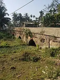
Namdang Stone Bridge | |
|---|---|
 | |
| Coordinates | 26°57′01″N 94°32′43″E / 26.9503891°N 94.5451547°E |
| Crosses | Namdang River |
| Locale | Sibsagar, Assam |
| Maintained by | Govt of Assam |
| Characteristics | |
| Design | Arch bridge |
| Material | Stone |
| Total length | 60 m |
| Width | 6.5 m |
| History | |
| Construction end | 1703 |
| Location | |
The Namdang Stone Bridge is a historic bridge located a few kilometers away from Sibsagar town in Assam, India. It was constructed in 1703 by craftmen brought from Bengal during the reign of Ahom king Rudra Singha. The bridge is 60 m (200 ft) long, 6.5 m (21 ft) wide and 1.7 m (5.6 ft) high. It runs over the Namdang (Tai-Ahom : Nam= Water; Dang=Red) river, a tributary of the Dikhou river. The present National Highway 37 is passing over it. The unique characteristic of the bridge is that it was cut out from a single solid piece of rock hundred years of age.
The bridge is a little curved in shape. The bridge connects Sibsagar town to Jorhat and other districts in the west.[1][2]
History
King Pratap Singha built a town on its bank and much later Rudra Singha constructed a masonry bridge over it. According to Peter Wade, the Namdang bridge was regarded as the western gate of the military capital of Rangpur, and was capable of being rendered a post of great strength, as the Moamoria rebels experienced. Many battles were fought in the vicinity during the reign of Gaurinath Singha and the Moamaria rebels. In 1825 a decisive battle took place between the British East India Company and Burmese in the bank of the Namdang river.
See also
References
- ↑ "Namdang Stone Bridge". Maps Of India. Archived from the original on 4 June 2009. Retrieved 25 April 2010.
- ↑ Sajnani, Manohar (2001). "Management Resources". Encyclopaedia of tourism resources in India. Vol. 1. p. 20. ISBN 9788178350172.
External links