Narayanpur | |
|---|---|
Community development block | |
 Narayanpur Location in Darbhanga, India  Narayanpur Narayanpur (India) | |
| Coordinates: 25°47′43″N 86°16′51″E / 25.795235°N 86.280806°E | |
| Country | |
| State | Bihar |
| District | Darbhanga |
| Government | |
| • Type | Community development block |
| Elevation | 250 m (820 ft) |
| Population (2011) | |
| • Total | 163,993 |
| Languages Urdu, Hindi, Maithili | |
| • Official Urdu, Hindi, Mathili | Hindi, Maithili |
| Literacy (2011) | |
| • Total literates | 72,725 (55.72%) |
| Time zone | UTC+5:30 (IST) |
| PIN | 847239 (Darbhanga) |
| Telephone/STD code | 06272 |
| Vehicle registration | BR-07 |
| Lok Sabha constituency | Darbhanga |
| Vidhan Sabha constituency | Darbhanga |
| Website | darbhanga |
| CD Block | |
Narayanpur is a community development block that forms an administrative division in Darbhanga district, Bihar state, India. It is located 24 km (15 mi) from Darbhanga, the district headquarters.

Narayanpur is a village with a population of 2,655 as per 2011 census,[1] Narayanpur is a village it is rapidly developing like a town. NH 57 is very near to this village and a railway junction is also present at distance of 2 km (1.2 mi).

Urdu is the local language in the Narayanpur area. Maithili is also spoken by a considerable number of people. Hindi is also spoken in the region. There is also a local unknown(mixture of Maithili and Urdu ) language is being spoken by the Muslim community.
Geography
The climate of this region is moderate climate .local winds like loo blow in a summer. There are two ponds which are locally called Daiwali pokhar (pond) located in west direction while Dalaukhar (pond) is in the east direction. There is balanced ecosystem, a series of mango orchids are being planted with different types of species.

Religious place
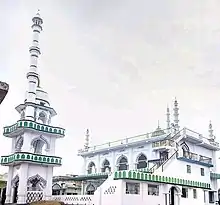
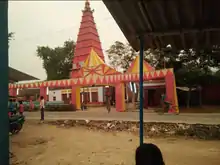
There are four beautiful mosques, Jama Masjid is one of them where people gather for a Friday prayer. There is also a temple located in the centre of the market which is locally called Bazaar.
Agriculture
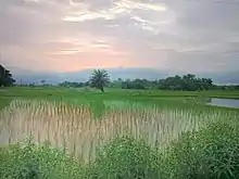
Economically peoples are mostly engaged in agricultural activities, farmers have a small land holding where they practice traditional modes of agriculture since land is fertile so all types of crops are being grown but for paddy crops. Farmers are highly dependent on monsoon just because of a lack of availability of means of irrigation.
Schools and colleges
There is one middle school (Maqtab) an Urdu medium and also an old Madrasa (Islamic school), Madrasa Ilahiya are being run by the Government of Bihar and there's many government schools. Apart from the government school there are various private schools including the oldest private School, Sun Flower School, New Doon Public School, and Kidzee International Pre-School. There is also a college almost 3.7 km (2.3 mi) away from Narayanpur village, Nehra, Where students enroll their name for intermediate undergraduate level courses.
References
- ↑ "Population by religion community. – 2011". Census of India, 2011. The Registrar General & Census Commissioner, India. Archived from the original on 25 August 2015.