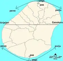
A map of Nauru describing the Nauruan navigational system
The Nauruan navigational system is a way of expressing direction, similar to North, South, East and West, but limitations in the system mean that it is unable to be used outside of Nauru.
The four main directions are pago, poe, pawa and pwiju (pwijiuw). Other directions include Gankoro and Arijeijen.[1]
References
- ↑ "2012 年世界南島學術研究計畫 成果報告 海潮之律:諾魯鄰海社會之生產和飲食的 即興節奏", 2012. (Taiwanese) (Archived)
This article is issued from Wikipedia. The text is licensed under Creative Commons - Attribution - Sharealike. Additional terms may apply for the media files.
