Needmore, Kentucky | |
|---|---|
 Needmore, Kentucky | |
| Coordinates: 37°39′06″N 84°52′40″W / 37.65167°N 84.87778°W | |
| Country | United States |
| State | Kentucky |
| County | Boyle |
| Elevation | 938 ft (286 m) |
| Time zone | UTC-5 (Eastern (EST)) |
| • Summer (DST) | UTC-4 (EDT) |
| Area code | 859 |
| GNIS feature ID | 499220[1] |
Needmore is an unincorporated community in Boyle County, Kentucky, United States. Needmore is located on U.S. Route 150 5.8 miles (9.3 km) west of Danville.[2]
References
- ↑ "Needmore". Geographic Names Information System. United States Geological Survey, United States Department of the Interior.
- ↑ State Primary Road System: Boyle County (PDF) (Map). Kentucky Transportation Cabinet. 2011. Retrieved May 30, 2013.
Municipalities and communities of Boyle County, Kentucky, United States | ||
|---|---|---|
| Cities | 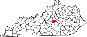 Location of Boyle County, Kentucky | |
| Unincorporated communities | ||
| Footnotes | ‡This populated place also has portions in an adjacent county | |
This article is issued from Wikipedia. The text is licensed under Creative Commons - Attribution - Sharealike. Additional terms may apply for the media files.