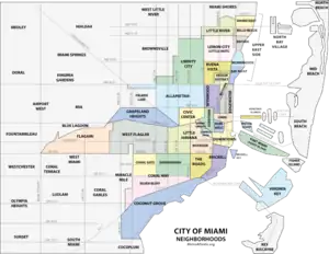

This is a list of neighborhoods in Miami in Miami-Dade County, Florida, United States. Many of the city's neighborhoods have been renamed, redefined and changed since the city's founding in 1896. As such, the exact extents of some neighborhoods can differ from person to person. The following is the list of all the city's major neighborhoods, including any corresponding sub-neighborhoods within them.
Brickell is at the center of the Miami core. Its borders are Interstate 95 to the west, Brickell Bay to the east, the Miami River to the north, and Rickenbacker Causeway to the south. Coconut Grove is an example of a neighborhood whose size and name has stayed relatively the same since its settlement in 1825. Having been settled originally as "Cocoanut Grove", its character has stayed almost intact from its early days.[1] In contrast, other neighborhoods have undergone many name and size changes. Buena Vista was once a much larger neighborhood in the 1920s, than it is today. Buena Vista once consumed all of the Miami Design District as well as a large part of Little Haiti, Wynwood and Edgewater. Other neighborhoods, such as the Arts & Entertainment District, were previously branded as "Omni", after the Omni Mall that was located there in the 1980s and 1990s. Midtown emerged as a new neighborhood in the mid-2000s after developers created the large scale Midtown Miami development in an area traditionally known as Edgewater.
See also
References
- ↑ Planning Your Vacation in Florida, Miami and Dade County [WPA Guide to Miami], Northport, NY: Bacon, Percy & Daggett, 1941, page 49.
- ↑ "Mapping America: Every City, Every Block". The New York Times. 13 December 2010 – via www.nytimes.com.

