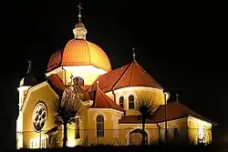
Nekla | |
|---|---|
 Church of Saint Andrew the Apostle | |
 Coat of arms | |
 Nekla | |
| Coordinates: 52°22′N 17°25′E / 52.367°N 17.417°E | |
| Country | |
| Voivodeship | Greater Poland |
| County | Września |
| Gmina | Nekla |
| Area | |
| • Total | 19.79 km2 (7.64 sq mi) |
| Population (2006) | |
| • Total | 3,203 |
| • Density | 160/km2 (420/sq mi) |
| Time zone | UTC+1 (CET) |
| • Summer (DST) | UTC+2 (CEST) |
| Postal code | 62-330 |
| Vehicle registration | PWR |
| National roads | |
| Website | http://www.nekla.eu/ |
Nekla [ˈnɛkla] is a town in Września County, Greater Poland Voivodeship, Poland, with 6,750 inhabitants (2004). It is situated on the Moskawa River, a tributary of Warta.
History
.jpg.webp)
As part of the region of Greater Poland, i.e. the cradle of the Polish state, the area formed part of Poland since its establishment in the 10th century. Nekla was a private village of Polish nobility, and later a private town, administratively located in the Pyzdry County in the Kalisz Voivodeship in the Greater Poland Province of the Kingdom of Poland.[1] A route connecting Warsaw with Poznań and Dresden ran through the town in the 18th century and King Augustus III of Poland often traveled that route.[2]
During the German invasion and occupation of Poland (World War II), the local Polish people were subjected to various atrocities. Already on September 12, 1939, the Einsatzgruppe VI committed a massacre of several Poles.[3] Several prominent Poles from Nekla were among the victims of a massacre of Poles committed by the Germans in nearby Kostrzyn on October 20, 1939 as part of the genocidal Intelligenzaktion campaign.[4][5] The Polish resistance movement was present in Nekla. In 1944, the Gestapo arrested the commander of the local unit of the Home Army, who was then imprisoned in Żabikowo and the Mauthausen concentration camp, yet he survived and returned to Nekla in 1947, where he became a school principal.[6]
References
- ↑ Atlas historyczny Polski. Wielkopolska w drugiej połowie XVI wieku. Część I. Mapy, plany (in Polish). Warszawa: Instytut Historii Polskiej Akademii Nauk. 2017. p. 1b.
- ↑ "Informacja historyczna". Dresden-Warszawa (in Polish). Retrieved 28 November 2023.
- ↑ Encyklopedia konspiracji Wielkopolskiej 1939–1945 (in Polish). Poznań: Instytut Zachodni. 1998. p. 147. ISBN 83-85003-97-5.
- ↑ Rubiś, Daniel (2011). "Początki okupacji niemieckiej w Wielkopolsce na przykładzie Kostrzyna". Biuletyn Instytutu Pamięci Narodowej (in Polish). No. 5–6 (126–127). IPN. p. 60. ISSN 1641-9561.
- ↑ Wardzyńska, Maria (2009). Był rok 1939. Operacja niemieckiej policji bezpieczeństwa w Polsce. Intelligenzaktion (in Polish). Warszawa: IPN. p. 194.
- ↑ Encyklopedia konspiracji Wielkopolskiej 1939–1945 (in Polish). Poznań: Instytut Zachodni. 1998. p. 547. ISBN 83-85003-97-5.