| Nepryadva | |
|---|---|
 | |
| Native name | Непрядва (Russian) |
| Location | |
| Country | Russia |
| Physical characteristics | |
| Mouth | Don |
• coordinates | 53°39′52″N 38°39′06″E / 53.6645°N 38.6516°E |
| Length | 67 km (42 mi) |
| Basin size | 799 km2 (308 sq mi) |
| Basin features | |
| Progression | Don→ Sea of Azov |
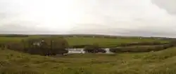
The Nepryadva (Russian: Непрядва) is a right tributary of the Don river in Tula Oblast, Russia. The river is 67 km long and its catchment area comprises 799 square kilometers.[1]
Near the mouth of the river the Battle of Kulikovo was fought in the late summer of 1380.
References
See also
This article is issued from Wikipedia. The text is licensed under Creative Commons - Attribution - Sharealike. Additional terms may apply for the media files.