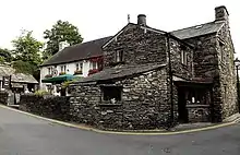
The New Hall Inn, also known as the Hole in t'Wall, is the oldest public house in Bowness-on-Windermere, and is a Grade II listed building.
History
The building, located on Lowside, Bowness, dates from around 1650.[1]
Thomas Longmire, a noted wrestler of his era, was landlord of the inn between 1852 and 1862.[2]
The New Hall Inn gained its pub licence in 1866.[3]
The New Hall Inn was acquired by John Booth of the Old Brewery, Ulverston, in 1880, and numerous changes to the pub were made.[4][5]
The pub was one of the largest in Bowness by 1890, by which time it was known locally as the "Hole in the Wall", or "Hole in t'Wall" in regional dialect.[5] The origin of the name is not entirely certain; there may have been in a literal hole in the wall of the building to pass drinks to the neighbouring blacksmith and ostlers.[6]
The inn was the oldest licensed house in Bowness by 1907, and appealed to a working class clientele, particularly boatmen.[7]
A 1931 account describes the pub as a place where dominoes and darts could be played, and where mild beer was served.[8]
The building gained its Grade II listing in 1973.[9]
Robinsons Brewery acquired the pub in 1982.[10]
References
- ↑ "Bowness Conservation Area". Lake District National Park. 22 November 2010. Retrieved 27 September 2018.
- ↑ "Renewal of New Hall Inn, Bowness". Lakes Herald. 11 June 1909.
- ↑ "The New Hall Inn". Lakes Chronicle and Reporter. 10 March 1909.
- ↑ "Sale of Property". Kendal Mercury. 20 August 1880.
- 1 2 "Public House Chat". Lakes Herald. 13 June 1890.
- ↑ Jules Brown (24 January 2013). The Rough Guide to the Lake District. Rough Guides Limited. p. 61. ISBN 978-1-4093-6505-1.
- ↑ "The New Hall Inn Licence". Lakes Chronicle and Reporter. 13 March 1907.
- ↑ "Attempt to change seats". Lancashire Evening Post. 4 July 1931.
- ↑ "HOLE IN T'WALL PUBLIC HOUSE, WITH ATTACHED BUILDINGS TO SOUTH". Historic England. Retrieved 27 September 2018.
- ↑ "Frederic Robinson". Financial Times. No. 28, 841. 3 August 1982.
54°21′54″N 2°55′15″W / 54.3649°N 2.9209°W