Niketan
নিকেতন | |
|---|---|
Urban area of Dhaka City | |
| Niketan Residential Area, Gulshan Niketan Housing Society | |
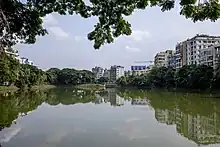
.jpg.webp) A neighbourhood in Niketan | |
| Coordinates: 23°46′29″N 90°24′43″E / 23.774594°N 90.412003°E | |
| Country | Bangladesh |
| Division | Dhaka |
| Municipal corporation | Dhaka North City Corporation |
| District | Dhaka District |
| Police Station | Gulshan Police Station, H-32, 115 Gulshan Avenue, Gulshan-2[1] |
| Time zone | UTC+06:00 (BST) |
| Area code | 1212 |
| Website | Niketan Society |
Niketan (Bengali: নিকেতন) also known as Niketan Residential Area, Gulshan or Niketan Housing Society is an upscale residential area in Dhaka, Bangladesh. It was a housing project of Eastern Housing Limited.[2] Niketan is also a part of Gulshan Thana and Ward No. 20 of Dhaka North City Corporation.[3]
History
Niketan Residential Area, Gulshan also known as Niketan Housing Society was a housing project of Eastern Housing Limited. The name of the area society is Niketan Welfare Society. This Residential Area has 5 gates. In the place of this suburb, there was an old village named Bhola Gram.[4][5] Gulshan was founded as a planned model town in 1961 with its own Pourashabha (municipal corporation), while the neighbouring Banani was founded in 1964. Gulshan Thana was established in 1972.[6] Gulshan Pourashabha was abolished in 1982.[7] In 1984, Gulshan, along with Mirpur municipality, was absorbed into Dhaka.[8]
Geography
Niketan is located at 23°46′29″N 90°24′43″E / 23.774594°N 90.412003°E. Niketan is surrounded by Gulshan-1, Mohakhali,[9] Tejgaon and Hatirjheel areas. It has a lake called Gulshan Lake. Niketan area has a total of fourteen roads, and the road numbers are 1, 2, 3, 4, 5, 6, 7, 8, 9, 10, 11, 12, 13, and 14. The Niketan area also has blocks, and the blocks are A, B, C, D, E, F, G, and H. There is a park called Shahid Dr. Fazle Rabbi Park right next to Niketan.[10][11]
Gallery
.jpg.webp) A Neighborhood in Niketan
A Neighborhood in Niketan Partial view of Niketan, Gulshan and Mohakhali areas of Gulshan Thana
 Gulshan Lake
References
- ↑ "Find Your Local Police – Dhaka Metropolitan Police". Archived from the original on 2023-05-13. Retrieved 2023-08-11.
- ↑ "NGA GeoName Database". National Geospatial-Intelligence Agency. Archived from the original on 2022-09-27. Retrieved 2016-01-12.
- ↑ "Population Census 2011: Dhaka Table C-01" (PDF). Bangladesh Bureau of Statistics. Retrieved 18 July 2023.
- ↑ "গুলশান ভুলে গেছে ভোলা গ্রামের কথা". Rising BD (in Bengali). Archived from the original on 2023-04-23. Retrieved 2023-08-11.
- ↑ "OP-ED: Can a city be equal for all?". 21 November 2020. Archived from the original on 13 May 2023. Retrieved 11 August 2023.
- ↑ Ahmed, Syed Shabbir (2012). "Gulshan Thana". In Islam, Sirajul; Jamal, Ahmed A. (eds.). Banglapedia: National Encyclopedia of Bangladesh (Second ed.). Asiatic Society of Bangladesh. Archived from the original on 2023-04-19. Retrieved 2023-08-11.
- ↑ Ghafur, Shayer (21 April 2006). "The Future of Gulshan South Park". Daily Star. Archived from the original on 2007-04-30. Retrieved 2006-11-15.
- ↑ Syed Ali Mortuza, Rural-urban Migration in Bangladesh: Causes and Effects, page 59, Dietrich Reimer, Berlin 1992
- ↑ "From Niketan to Mohakhali: A Rickshaw Odyssey". The Daily Star. 2017-07-17. Archived from the original on 2023-12-02. Retrieved 2023-12-06.
- ↑ "Yellow rickshaw scheme misses the mark". Dhaka Tribune. 2016-10-16. Archived from the original on 2023-11-14. Retrieved 2023-12-06.
- ↑ "DNCC to set up app-based parking locations in Gulshan to reduce traffic slowdowns". bdnews24.com. 2022-11-14. Archived from the original on 2023-11-14. Retrieved 2023-12-06.