Nong Sano
หนองสะโน | |
|---|---|
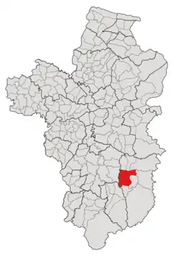
 Subdistrict location in Ubon Ratchathani province | |
| Country | Thailand |
| Province | Ubon Ratchathani |
| District | Buntharik |
| Number of Muban | 20 |
| Number of Mu | 23 |
| Subdistrict established | 1969 |
| Area | |
| • Total | 145 km2 (56 sq mi) |
| Population (2021) | |
| • Total | 16,973 |
| • Density | 117.06/km2 (303.2/sq mi) |
| Time zone | UTC+7 (ICT) |
| Postal code | 34230 |
Nong Sano (Thai: หนองสะโน) is a tambon (subdistrict) located in the western region of Buntharik district, in Ubon Ratchathani Province, Thailand.[1][2][3] In 2021, it had a population of 16,973 people.[1] Neighbouring subdistricts are (clockwise from the south) Non Kho, Sok Saeng, Bua Ngam of Det Udom district, Na Pho, Ban Maet, Kho Laen, Phon Ngam and Bua Ngam of Buntharik.[2]
History
The subdistrict of Nong Sano was founded in 1969 by splitting off 11 villages in the westernmost area of the Phon Ngam subdistrict.[2][3]
Geography
The tambon covers 145 km2 and is located in the western region of the Buntharik district. The western part features undulating terrain, while the remainder is primarily low river plains of the Lam Dom Noi River. (ลำโดมน้อย).[4]
Administration
The subdistrict of Nong Sano is divided into 20 villages (mubans; หมู่บ้าน), two of which, Nong Sano and Non Laing villages, were further divided into three and two community groups (Mu; หมู่), respectively.[1] The entire area has been governed by the Subdistrict Administrative Organization of Nong Sano (องค์การบริหารส่วนตำบลหนองสะโน; Nong Sano SAO).[1][3]
As of the 2021 census, it had a population of 16,973 people with 5,195 households. The following is a list of the subdistrict's mubans, which roughly correspond to the villages.[1]
| Village | Group (Mu) | Household | Population | |
|---|---|---|---|---|
| Romanized name | Thai name | |||
| Nong Sano | หนองสะโน | 1 | 296 | 871 |
15 | 174 | 614 | ||
19 | 226 | 803 | ||
| Nong Muang | หนองม่วง | 2 | 205 | 586 |
| Non Chan | โนนจันทร์ | 3 | 213 | 623 |
| Non Laing | โนนเลียง | 4 | 290 | 870 |
16 | 208 | 648 | ||
| Non Chik | โนนจิก | 5 | 175 | 676 |
| Sang Muang | สร้างม่วง | 6 | 249 | 824 |
| Som Siaw | ส้มเสี้ยว | 7 | 212 | 584 |
| Na Dom | นาโดม | 8 | 212 | 727 |
| Udom Chat | อุดมชาติ | 9 | 334 | 1,048 |
| Somphon Rat | สมพรรัตน์ | 10 | 179 | 626 |
| Jong Charoen | จงเจริญ | 11 | 419 | 1,300 |
| Pho Ngoen | โพธิ์เงิน | 12 | 307 | 1,161 |
| That Nang Phaya | ธาตุนางพญา | 13 | 211 | 581 |
| Krung Charoen | กรุงเจริญ | 14 | 132 | 304 |
| Muang Charoen | ม่วงเจริญ | 17 | 232 | 847 |
| Non Saen Suk | โนนแสนสุข | 18 | 121 | 461 |
| Muang Ngam | ม่วงงาม | 20 | 242 | 847 |
| Nong Muang Tai | หนองม่วงใต้ | 21 | 165 | 512 |
| Vieng Kasem | เวียงเกษม | 22 | 245 | 824 |
| Somphon Rat Tai | สมพรรัตน์ใต้ | 23 | 148 | 636 |
| Central House Registration | 0 | 0 | ||
| Total | 5,195 | 16,973 | ||
References
- 1 2 3 4 5 "โครงสร้างข้อมูลสถิติจำนวนประชากร" (in Thai). Department of Provincial Administration of Thailand. 2021. Archived from the original on 14 December 2022. Retrieved 15 December 2022. Alt URL
- 1 2 3 "ประกาศกระทรวงมหาดไทย เรื่อง ตั้งและเปลี่ยนแปลงเขตตำบลในท้องที่อำเภอเดชอุดม อำเภอบุณฑริก อำเภอตระการพืชผล อำเภอพิบูลมังสาหาร อำเภอกุดชุม อำเภอยโสธร และอำเภอวารินชำราบ จังหวัดอุบลราชธานี" (PDF). www.ratchakitcha.soc.go.th (in Thai). Royal Thai Government Gazette. 29 July 1969. Archived from the original (PDF) on 1 August 2019. Retrieved 17 December 2022.
- 1 2 3 ภาณุภณ พสุชัยสกุล. "ประะวัติความเป็นมา". www.nongsano.go.th (in Thai). Subdistrict Administrative Organization of Nong Sano. Archived from the original on 12 July 2022. Retrieved 17 December 2022.
- ↑ "สภาพและข้อมูลพื้นฐาน". Nongsano.go.th (in Thai). Subdistrict Administrative Organization of Nong Sano. Archived from the original on 12 July 2022. Retrieved 17 December 2022.