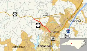
North Carolina Highway 153 | ||||
|---|---|---|---|---|
 | ||||
| Route information | ||||
| Maintained by NCDOT | ||||
| Length | 2.9 mi[1] (4.7 km) | |||
| Existed | 1930–present | |||
| Major junctions | ||||
| West end | ||||
| East end | Main Street in Landis | |||
| Location | ||||
| Country | United States | |||
| State | North Carolina | |||
| Counties | Rowan | |||
| Highway system | ||||
| ||||
North Carolina Highway 153 (NC 153) is a 2.9-mile-long (4.7 km) primary state highway in the U.S. state of North Carolina. The highway serves as a spur of NC 152 into Landis.
Route description
NC 153 is a short two-lane highway that traverses 2.9 miles (4.7 km), from NC 152 to Landis.
History
Established in 1930 as a new primary routing, from NC 152 to NC 15 (which later became US 170, followed by US 29 and US 29A before finally becoming a secondary road); little has changed since.
Junction list
The entire route is in Rowan County.
| Location | mi[1] | km | Destinations | Notes | |
|---|---|---|---|---|---|
| | 0.0 | 0.0 | |||
| Landis | 2.9 | 4.7 | Main Street | ||
| 1.000 mi = 1.609 km; 1.000 km = 0.621 mi | |||||
References
- 1 2 Google (November 24, 2013). "North Carolina Highway 153" (Map). Google Maps. Google. Retrieved November 24, 2013.
External links
Template:Attached KML/North Carolina Highway 153
KML is from Wikidata
 Media related to North Carolina Highway 153 at Wikimedia Commons
- NCRoads.com: N.C. 153
This article is issued from Wikipedia. The text is licensed under Creative Commons - Attribution - Sharealike. Additional terms may apply for the media files.
