North Carolina Highway 58 | ||||
|---|---|---|---|---|
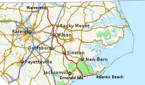 Route of NC 58 highlighted in red | ||||
| Route information | ||||
| Maintained by NCDOT | ||||
| Length | 175.8 mi[1] (282.9 km) | |||
| Existed | 1920s[2]–present | |||
| Major junctions | ||||
| South end | Fort Macon State Park in Atlantic Beach | |||
| North end | ||||
| Location | ||||
| Country | United States | |||
| State | North Carolina | |||
| Counties | Carteret, Jones, Lenoir, Greene, Wilson, Nash, Franklin, Warren | |||
| Highway system | ||||
| ||||

North Carolina Highway 58 (NC 58) is a primary state highway in the U.S. state of North Carolina that traverses the state's Coastal Plain. The route links many of the Crystal Coast communities along its eastern segment. Its southern terminus is at the visitor center parking lot for Fort Macon State Park in Atlantic Beach and its northern terminus is at the intersection of US 401 and US 158 Business in Warrenton. The highway traverses nearly the entire length of the Bogue Banks and serves the major cities of Kinston, Snow Hill, and Wilson.
Route description
NC 58 begins from the visitor center parking lot at Fort Macon State Park--formerly County Road 1190--and begins heading west along Bogue Banks. It passes through Atlantic Beach, Pine Knoll Shores, Indian Beach, and Emerald Isle as it runs along the Bogue Banks as a main highway. Approaching the west end, the highway turns north and crosses on the Emerald Island Causeway. Running by Cedar Point, the highway intersects NC 24 and then heads toward the northwest as it passes by the White Oak River Mechanical Harvesting of Oysters Prohibited Area. The route then approaches Maysville and runs concurrent with US 17 heading north until reaching Pollocksville where NC 58 splits from US 17 heading west. The highway approaches Trenton and runs concurrent with NC 41 for about 2.9 miles (4.7 km). NC 58 then enters Kinston and runs concurrent with US 70 until reaching the intersection with US 258, where the route turns to the north and runs concurrent with US 70 Bus. and US 258 Bus., crossing over the Neuse River via Frederick Jones Bridge. Heading through downtown, the highway begins running concurrently with NC 11 until reaching the intersection with Vernon Avenue, where NC 58 splits from US 70 Bus., US 258 Bus. and NC 11. NC 11 heads east while the business routes head west.
The route then continues north after exiting Kingston and intersects NC 123 and US 258 before entering Snow Hill. It then runs concurrent with US 13 for about 1.3 miles (2.1 km). The highway then continues northwest and intersects and runs concurrent with NC 222 through Stantonsburg. It then interchanges with I-587 and US 264 and then runs concurrent with US 264 Alt. for 1.6 miles (2.6 km), intersecting NC 91 and US 301 before entering downtown Wilson. Exiting town, the highway intersects NC 42, a belt route around Wilson as it exits town. Heading north towards Nashville, NC 58 intersects NC 97 and crosses over Interstate 95 but does not have direct access to the freeway. As it enters Nashville, the route then runs concurrent with US 64 Bus. for 0.5 miles (0.80 km). It interchanges US 64 (future Interstate 87 corridor). The highway then continues north and passes through Castalia before intersecting the eastern terminus of NC 56. Then, NC 58 intersects NC 43 before entering Warrenton, running concurrent with US 158 Bus. and then reaching its northern terminus at US 401.
Major intersections
| County | Location | mi[1] | km | Destinations | Notes |
|---|---|---|---|---|---|
| Carteret | Atlantic Beach | 0.0 | 0.0 | Fort Macon State Park | |
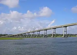
| Bogue Sound | 21.3– 22.1 | 34.3– 35.6 | B. Cameron Langston Bridge | ||
| Cedar Point–Cape Carteret line | 22.8 | 36.7 | |||
| Jones | Maysville | 41.2 | 66.3 | Southern end of US 17 concurrency | |
| Ravenswood | 48.2 | 77.6 | Northern end of US 17 concurrency | ||
| Trenton | 58.0 | 93.3 | Southern end of NC 41 concurrency | ||
| | 60.9 | 98.0 | Northern end of NC 41 concurrency | ||
| Lenoir | Kinston | 77.5 | 124.7 | Southern end of US 70 concurrency | |
| 78.4 | 126.2 | Northern end of US 70 concurrency; southern end of US 70 Bus. / US 258 Bus. concurrency | |||
| 79.3 | 127.6 | ||||
| 80.0 | 128.7 | Nouthern end of US 70 Bus. / US 258 Bus. concurrency | |||
| | 84.8 | 136.5 | Northern terminus of NC 148 | ||
| Greene | Glenfield Crossroads | 89.5 | 144.0 | Southern terminus of NC 123 | |
| Snow Hill | 94.1 | 151.4 | Southern end of US 258 Truck concurrency | ||
| 95.4 | 153.5 | Southern end of NC 903 concurrency | |||
| 95.6 | 153.9 | Northern end of US 258 Truck / NC 903 concurrencies; southern end of US 13 concurrency | |||
| | 96.8 | 155.8 | Northern end of US 13 concurrency | ||
| Wilson | Stantonsburg | 109.8 | 176.7 | Southern end of NC 111 / NC 222 concurrency | |
| 110.2 | 177.3 | Northern end of NC 111 / NC 222 concurrency | |||
| | 115.1– 115.3 | 185.2– 185.6 | Exit 49 (I-587/US 264) | ||
| Wilson | 117.4 | 188.9 | Southern end of US 254 Alt. concurrency | ||
| 118.9 | 191.4 | Northern end of US 254 Alt. concurrency; southern end of US 301 concurrency | |||
| 119.4 | 192.2 | Northern end of US 301 concurrency | |||
| 120.0 | 193.1 | Southern end of NC 42 concurrency | |||
| 123.0 | 197.9 | Northern end of NC 42 concurrency | |||
| Nash | Winstead Crossroads | 129.7 | 208.7 | ||
| Nashville | 139.5 | 224.5 | Southern end of US 64 Bus. concurrency | ||
| 140.0 | 225.3 | Northern end of US 64 Bus. concurrency | |||
| 140.4– 140.5 | 226.0– 226.1 | Exit 459 (US 64) | |||
| | 150.9 | 242.9 | Eastern terminus of NC 56 | ||
| Franklin | Centerville | 158.2 | 254.6 | ||
| Warren | Liberia | 171.1 | 275.4 | Northern terminus of NC 43 | |
| | 175.3 | 282.1 | Southern end of US 158 Bus. concurrency | ||
| Warrenton | 175.8 | 282.9 | Northern end of US 158 Bus. concurrency | ||
1.000 mi = 1.609 km; 1.000 km = 0.621 mi
| |||||
References
- 1 2 Google (May 16, 2015). "North Carolina Highway 58" (Map). Google Maps. Google. Retrieved May 16, 2015.
- ↑ NCRoads - NC 58 Archived February 16, 2007, at the Wayback Machine
External links
![]() Media related to North Carolina Highway 58 at Wikimedia Commons
Media related to North Carolina Highway 58 at Wikimedia Commons