| North Greenbushes Western Australia | |||||||||||||||
|---|---|---|---|---|---|---|---|---|---|---|---|---|---|---|---|
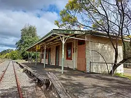
 The heritage-listed Greenbushes Railway Station | |||||||||||||||
| Coordinates | 33°49′S 116°04′E / 33.82°S 116.06°E | ||||||||||||||
| Population | 174 (SAL 2021)[1] | ||||||||||||||
| Postcode(s) | 6254 | ||||||||||||||
| Area | 18.5 km2 (7.1 sq mi) | ||||||||||||||
| Location |
| ||||||||||||||
| LGA(s) | Shire of Bridgetown–Greenbushes | ||||||||||||||
| State electorate(s) | Warren-Blackwood | ||||||||||||||
| Federal division(s) | O'Connor | ||||||||||||||
| |||||||||||||||
North Greenbushes is a rural locality and small town of the Shire of Bridgetown–Greenbushes in the South West region of Western Australia.[2][3]
The Shire of Bridgetown–Greenbushes is located on the traditional land of the Bibulman (also spelled Bibbulmun or Pibelmen)[4][5] and Wardandi (also spelled Wadandi) people,[6][7] both of the Noongar nation.[8][9]
Tin was discovered around Greenbushes in 1888, which led to the development of the area as a mining location. In 1898, a train station was opened in North Greenbushes on the Donnybrook to Bridgetown railway, originally just named Greenbushes. A town was subsequently gazetted three kilometres to the south the following year; it received the name Greenbushes, resulting in the location of the railway station being renamed to North Greenbushes.[10]
The Greenbushes Railway Station, opened in October 1898 as a station for both passengers and goods, is heritage-listed but no longer in use, passenger services on the line having been suspended in 1985. The other buildings at the site, the goods shed and station master's house, have been demolished or destroyed by fire.[11]
References
- ↑ Australian Bureau of Statistics (28 June 2022). "North Greenbushes (suburb and locality)". Australian Census 2021 QuickStats. Retrieved 28 June 2022.
- ↑ "SLIP Map". maps.slip.wa.gov.au. Landgate. Retrieved 18 August 2023.
- ↑ "NationalMap". nationalmap.gov.au. Geoscience Australia. Retrieved 18 August 2023.
- ↑ "Pibelmen". www.boodjar.sis.uwa.edu.au. University of Western Australia. Retrieved 18 August 2023.
- ↑ "Pibelmen (WA)". www.samuseum.sa.gov.au. South Australian Museum. Retrieved 18 August 2023.
- ↑ "Wardandi". www.boodjar.sis.uwa.edu.au. University of Western Australia. Retrieved 18 August 2023.
- ↑ "Wardandi (WA)". www.samuseum.sa.gov.au. South Australian Museum. Retrieved 18 August 2023.
- ↑ "Map of Indigenous Australia". aiatsis.gov.au. Australian Institute of Aboriginal and Torres Strait Islander Studies. Retrieved 18 August 2023.
- ↑ "Home". www.bridgetown.wa.gov.au. Shire of Bridgetown–Greenbushes. Retrieved 18 August 2023.
We acknowledge the cultural custodians of the land, the Pibulmun-Wadandi people
- ↑ "History of country town names – N". Western Australian Land Information Authority. Archived from the original on 14 March 2022. Retrieved 18 August 2023.
- ↑ "Greenbushes Railway Station". inherit.stateheritage.wa.gov.au. Heritage Council of Western Australia. Retrieved 18 August 2023.