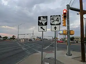
Northeast El Paso is part of the city of El Paso, Texas and is located north of Central El Paso, and east of the Franklin Mountains. Its southern boundary is variously given as Fred Wilson Boulevard or Cassidy Road and Van Buren Avenue, and it extends northward to the New Mexico state line; some portions of this region lie outside the city limits, including parts of Franklin Mountains State Park and areas of Fort Bliss: the Logan Heights area of Fort Bliss around Chapin High School and Castner Range National Monument, an old firing range northwest of Hondo Pass Drive and Gateway South Boulevard. Development of Northeast El Paso, which had begun before the Second World War around the Logan Heights area, started in earnest during the 1950s, when many homes were demolished in the process of the construction of Interstate 10. It is one of the more ethnically diverse areas of town due to a high concentration of military families. Northeast El Paso has historically not developed at a rate comparable to East El Paso and Northwest El Paso, but in recent years, it has seen an increase in development. It is expected that the population in Northeast El Paso will grow more rapidly as a result of the troop increase for Fort Bliss in the coming years. Northeast El Paso has gained recognition throughout the city for schools like Parkland, Irvin, Andress and Chapin because of their outstanding athletic programs.
History
Northeast El Paso was once an un-mapped open plain prior to the 1880s, when the first surveys of the area took place.[1] The area was first called La Noria, which means "the well," and which was suggested by Mrs. Joseph Magoffin.[2] A cemetery was founded in the 1800s in the area now near Magoffin Middle School called the McGill Pauper Cemetery.[3] The cemetery was founded by a judge, Joseph McGill, and stopped accepting new burials in 2009.[3] In 1893, Fort Bliss was relocated to El Paso in the Northeast area.[4] In 1906, around 20,000 cattle grazed in the area.[5]
An important portion of the Northeast, the plats of Tobin, New Tobin and Nations Map of Tobin date to 1907.[2] In this area, Frank R. Tobin created a post office, electric plant, fire department and well.[5] An ad in the El Paso Herald touted that $1 was enough to get started in investing in "Nations' Tobin Town."[6] The community was owned by 1,200 people, but failed because it was too far away from the city of El Paso at the time.[7]
A small town called Lynchville grew up north of Fort Bliss and existed during World War I.[2] This land was then granted to Fort Bliss for the Sierra Madre housing project in World War II.[2] In 1955, the land was given back to the city.[2]
In 1926, Fort Bliss obtained land that became Biggs Field.[8]
Lots were platted in 1953 and 1954 along the edge of El Paso.[9] Mountain View plat was filed by Charles H. Foster in 1953-54.[9] The firm Haynesworth and Huckleberry filed the Tobin Park Plat in 1955.[9] Also in 1955, William Mayfield filed the Mountain Park plat.[9] The city also began to annex land going north, until in 1959, the city boundary was only five miles away from the Texas-New Mexico border.[9]
In 1960, the NorthPark Mall, made up of more than fifty stores was built on Dyer Street.[10] The outdoor mall opened on May 1, 1960 and was designed by the firm Nesmith and Lane and built by J.E. Morgan and Son and Karam Construction Company.[11] It cost around $800,000 to build and was an alternative to shopping in downtown El Paso.[10] It was also the largest shopping area in El Paso at the time.[11] During the 1960s, the mall was the "Northeast area's heartbeat," according to the El Paso Times.[11] By the late 70s and early 80s, Northgate faced competition from other malls and in the 1990s, it slowly died with store after store becoming boarded up.[11] The city purchased the property for $6 million.[11] After years of neglect, the mall was demolished in 2011.[12] Other major shopping areas include Sunrise Center and Rushfair.[13]
Demographics
The area had only 201 residents in 1950.[13] In 1953, there were around 8,000 residents.[9] There were around 84,000 people living in Northeast El Paso in 1960.[1] In 1964, the population had grown to 46,010.[13] The quick growth of Northeast El Paso after 1950 was due to the post-war housing boom which attracted young professionals to the area.[14]
According to El Paso Parks and Recreation public relations coordinator, Wayne Thornton, the Northeast "has the largest concentration of youth, especially teenagers, on the streets."[15]
Cityscape

Northeast El Paso is bounded by the Franklin Mountains, New Mexico, Fort Bliss and railroad tracks at Memorial Park.[1] In 1964, the Transmountain Road was approved in order to connect the northeast and northwest of El Paso across the Franklin Mountains.[16]One of the main thoroughfares through the Northeast is Dyer Street.[17] Former El Paso mayor, John Cook, said, "Dyer is very indicative of Northeast El Paso. It is our living room. When people see Dyer they see the Northeast."[17] Between Gateway North, Dyer street and Hondo Pass is the neighborhood known as Angel's Triangle.[18]
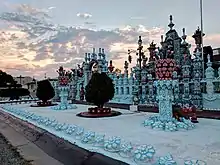
An unusual house known as the "Sugar House" is located in the Northeast.[19] The home is owned by Rufino Loya who started decorating his home with statues and mosaics starting in 1973.[19] The style is similar to art from Zacatecas.[19]
Neighborhoods
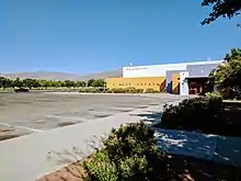
One of the neighborhoods in the area was once known as the Devil's Triangle, though after police and resident action, became known as the Angel's Triangle.[20] Other neighborhoods include Castner Heights, which is bordered by the Patriot Freeway, Diana Drive and Hondo Pass Drive.[21] Castner Heights has a neighborhood association of around 400 people as of 2009.[22] Castner Heights has faced controversy over the bright canary yellow that the local elementary school, Whitaker, was painted.[23] Logan Heights is a military housing area close to Fort Bliss.[24] The Milagro Hills neighborhood is bounded by Transmountain Road, Diana Street and Dyer Street.[25] In 2009, the neighborhood established the Milagro Hills Neighborhood Association.[26] Another neighborhood in the northeast is Mountain Park, which is built high into the Franklin Mountains.[13]
Healthcare
The William Beaumont Army General Hospital was opened on July 1, 1921 on an area that had once been a rifle range.[8] The name was changed to William Beaumont Army Medical Center and dedicated on July 1, 1972.[27]
Arts and culture
The Bowen Ranch is on the edge of Northeast El Paso and the Southern New Mexico border.[28] It's an 88,000 acre working ranch with a restaurant called the Edge of Texas Steakhouse and Saloon.[29][30] The ranch has been in the area since the 1800s where it was located along the Old Salt Trail.[30][28] Jimmy Bowen began working the ranch in 1953 and bought the land piece by piece over time.[28] There are four kinds of cattle raised on the ranch: Herefords, Brahmans, longhorns and Brafords.[28]
Area Museums

The Wilderness Park Museum, later known as the El Paso Museum of Archaeology, opened on October 12, 1977.[31] The mayor, Fred Hervey, paid for the construction himself, which cost $75,000.[31] This museum had dioramas about life before Spanish colonization of the area, a nature trail featuring a kiva, pithouse and Pueblo ruin and other exhibits.[32] The museum sponsors an annual Franklin Mountain Poppies Fest in the spring when the California poppies are in bloom.[33]
Parks and recreation
Residents of the Northeast feel that their parks and recreation areas are very important, according to the El Paso Times.[15] Recreation centers provide activities for families, children and teens to have interesting things to do in their own neighborhood.[15]
Grandview Park, on Jefferson Road was upgraded in 2005 to include an improved playground, new basketball courts, swimming pool and tennis courts.[34]
Todd Ware Park is located in the Castner Heights neighborhood and has a good view of the Franklin Mountains.[35] Improvements to the park were made in 2009 which included additional trash cans and better lighting.[35]
Nations Tobin Park

Frank Tobin established a rival town ten miles to the northeast of El Paso in the 1900s, but it was considered too far away and quickly failed.[13] Today, Nations Tobin Park lies on part of this area.[5] The original recreation center was built in 1961.[36] Currently, the Nation's Tobin Recreation Center includes a regulation-sized hockey rink with raised seating for 500 spectators.[37] The aquatic area was first opened in 1960.[36] The pool is L-shaped, 25 meters long and has showers and dressing rooms available.[38] At the end of the swimming season, the Nations Tobin Aquatic Center hosts a Dog Swim Day where dogs are allowed to swim in the pool and compete in various contests.[39] After the swim day, the city cleans and drains the outdoor pool for the season.[40] Dog Swim Day was first hosted on September 6, 2008.[41]
Veterans Park
Veterans Park, which also has the Northeast Recreation Center, was upgraded in 2005.[34] The park and rec center received a paved parking lot, repairs to fencing and additional picnic tables.[34] The recreation center provides day care, and there is also a pool at Veterans Park.[42]
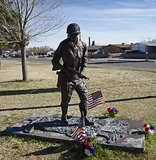
The southwest corner of the park, near the intersection of Salem and Rushing features the sculpture Days of Valor.

Other parks
McKelligon Canyon was purchased by El Paso County in 1931.[43] Federal relief money helped pay for a four-mile road into the canyon and originating at Alabama street.[44]
Castner Range is an area which is seeking national monument status and is located on the east slopes of the Franklin Mountains.[45] It's an area that takes up around 7,081 acres and is one of the largest natural spaces in El Paso.[45] Castner Range is part of the Chihuahuan Desert, home to over 100 different kinds of birds and is of archaeological significance, especially for the petroglyphs in the area.[45] Castner Range was an artillery range for Fort Bliss and has been unused since the 1970s.[46] In 2012, Representative Silvestre Reyes introduced a bill to transfer the area to the Franklin Mountains State Park.[47] In 2016, efforts were underway to petition President Barack Obama to declare the area a national monument.[45]
Community gardens
Community gardens are also present in the neighborhoods. The Weldon Yerby Senior Gardens are located in the Castner Heights neighborhood near the YWCA.[48] The Weldon Yerby garden is most likely the oldest community garden in El Paso, according to the El Paso Times.[49] Approximately 100 people contribute to and work on the garden which was started to encourage senior citizens to get exercise and eat healthier.[49]
Education
With the increase in population in the area, major public school construction was underway in the 1960s.[13] Public schools located in Northeast are in El Paso Independent School District (EPISD)[50] and Ysleta Independent School District (YISD). El Paso Independent Schools from Kindergarten - Grade 5 are 19 Elementary schools: Tom Lea, Barron, Nixon, Bradley, Fannin, Newman, Collins, Dowell, Schuster, Crosby, Whitaker, Stanton, H. R. Moye, Park, Robert E. Lee, Logan, Powell, Milam, and Bliss. Five Middle Schools: Richardson, HE Charles, Terrace Hills, Canyon Hills, and Maggofin. Five High Schools: Parkland, Andress, Transmountain Early College, Irvin, and Chapin.
Public Libraries
The Richard Burges Library Branch of the El Paso Public Library was once located next to NorthPark Mall on Dyer Street.[10] The Friends of the Northeast also ran a bookstore where NorthPark Mall once was located.[11] Richard Burges Branch is closed to the public beginning on November 6, 2017 for expansion and renovation funded by the 2012 Quality of Life Bond Issue. The completion estimate is one year. The project includes: New dedicated children’s room Public art piece designed by local artist Hal Marcus Expanded & dedicated computer lab Expanded community meeting room space Additional study room Dedicated and revitalized teen area Dedicated Friends of the Library bookstore Self-service check out stations[51]
Infrastructure
In 1951, residents faced a lack of water, possibly due to a lack of infrastructure for the Northeast.[52] A new sewer line was installed in the area in 1952.[53]
In 2014, it was announced that a solar power station, the Newman Solar Project, would be built in the Northeast.[54] This project was the largest solar project in El Paso in 2015.[55]
Industry
Residents in the Northeast began to complain about dust and damage to the Franklin Mountains due to the operation of the Hugh McMillan's rock quarry in 1953.[56][57] The quarry was located near McKelligan Canyon.[56]
Notable residents
References
Citations
- 1 2 3 Thomas 1966, p. 2.
- 1 2 3 4 5 Thomas 1966, p. 3.
- 1 2 Martinez, Aaron (5 January 2015). "The stories behind the forgotten cemetery in Northeast El Paso". El Paso Times.
- ↑ Thomas 1966, p. 6.
- 1 2 3 Thomas 1966, p. 4.
- ↑ "$1 Will Start You". El Paso Herald. 2 July 1908. Retrieved 28 June 2017 – via Newspapers.com.
- ↑ Metz 1993, p. 154.
- 1 2 Thomas 1966, p. 8.
- 1 2 3 4 5 6 Thomas 1966, p. 15.
- 1 2 3 Chávez, Adriana (3 December 2006). "NorthPark Mall Gets Cold Shoulder From Shoppers". El Paso Times.
- 1 2 3 4 5 6 Bracamontes, Aaron (1 August 2011). "New Life for Northgate Mall: City Hopes to Restore Luster to Northeast's Faded Gem". El Paso Times.
- ↑ Valdez, Diana Washington (26 September 2011). "Pull Out the Sledgehammer: Northpark Mall Demolition Begins". El Paso Times.
- 1 2 3 4 5 6 Hail, Marshall (5 August 1964). "Northeast El Paso Again on Upgrade". El Paso Herald-Post. Retrieved 28 June 2017 – via Newspapers.com.
- ↑ Palmore, William (July 2007). "Borderland Modernism". Texas Architect: 22–23.
- 1 2 3 Cooper, Kirk (17 June 2007). "Recreation centers eager to offer kids activities". El Paso Times.
- ↑ Thomas 1966, p. 16.
- 1 2 3 Torres, Zahira (29 March 2004). "Fighting Dyer straits; 'Living room' of Northeast could be rejuvenated". El Paso Times.
- ↑ Chávez, Adriana M. (22 July 2007). "Bedeviled: Angel's Triangle Trouble Returns". El Paso Times.
- 1 2 3 "Story+Gallery: Northeast El Paso's unique 'Sugar House' a Must-See". El Paso Herald-Post. 18 March 2017. Retrieved 2017-06-12.
- ↑ Forsyth 1998, p. 5-6.
- ↑ Chávez, Adriana M. (9 September 2007). "Misuse of park has area residents seeing red". El Paso Times.
- ↑ Flores, Aileen B. (26 October 2009). "Castner Heights neighborhood group elects new chief". El Paso Times.
- ↑ Hinojosa, Alex (23 August 2010). "Controversy continues over school's color". El Paso Times.
- ↑ Burge, David (28 October 2011). "$4.2 million redo: Logan Heights Physical Fitness Center greener". El Paso Times.
- ↑ Bracamontes, Aaron (9 May 2011). "Milagro Hills book outreach in Northeast El Paso may give impetus to neighbors group, too". El Paso Times.
- ↑ Flores, Aileen B. (13 April 2009). "Residents team up for Milagro association". El Paso Times.
- ↑ Metz 1993, p. 265.
- 1 2 3 4 Bracamontes, Aaron (21 September 2012). "Northeast El Paso rancher Jimmy Bowen dies". El Paso Times.
- ↑ "The Edge Of Texas Steak House El Paso Texas". www.edgeoftexassteakhouse.com. Retrieved 2017-06-15.
- 1 2 "Jimmy Bowen, head of Bowen Ranch dies at age 79". KVIA. 2014-03-06. Retrieved 2017-06-15.
- 1 2 Metz 1993, p. 269.
- ↑ Curlee, Kendall (12 June 2010). "El Paso Museum of Art". Handbook of Texas Online. Texas State Historical Association. Retrieved 12 June 2017.
- ↑ Prosoco, Susan (27 March 2014). "Out'n'About: Poppies flourish in time for annual festival". La Cruces Sun-News.
- 1 2 3 Torres, Zahira (14 February 2005). "Soon they'll double the leisure, double the fun; Northeast residents await renovation of two city parks". El Paso Times.
- 1 2 Flores, Aileen B. (6 April 2009). "Todd Ware Park improvements promote sense of safety, cleanliness". El Paso Times.
- 1 2 Flynn, Ken (7 February 1961). "El Paso Families Flock to Recreation Centers". El Paso Herald-Post. Retrieved 28 June 2017 – via Newspapers.com.
- ↑ Hunt, Darren (13 July 2003). "Man's Diligence Brings New Inline Hockey Facility". El Paso Times.
- ↑ "Nations-Tobin Park Pool Opens New Recreation Center Scheduled". El Paso Herald-Post. 23 July 1960. Retrieved 28 June 2017 – via Newspapers.com.
- ↑ Thornton, Wayne (6 September 2012). "Aquatic center will be going to the dogs". El Paso Times.
- ↑ Lopez, April (13 September 2009). "Canines cool off, compete before city drains pools". El Paso Times.
- ↑ Flores, Aileen B. (6 September 2008). "Pups pool their efforts on 1st-ever swim day". El Paso times.
- ↑ Bracamontes, Aaron (2 May 2011). "Veterans Park center participants return with own children years later". El Paso Times.
- ↑ Thomas 1966, p. 5.
- ↑ Thomas 1966, p. 13.
- 1 2 3 4 Martinez, Victor R. (21 October 2016). "Study could help Castner Range". Las Cruces Sun-News.
- ↑ Bracamontes, Aaron (12 May 2012). "Conserving Castner Range: Parts of Army land could expand state park". El Paso Times.
- ↑ "Rep. Silvestre Reyes announces legislation on Castner Range". El Paso Times. 12 May 2012.
- ↑ Chávez, Adriana (4 March 2007). "Seeds of cooperation save Senior Gardens". El Paso Times.
- 1 2 Valdez, Diana Washington (28 August 2015). "Community gardening grows across El Paso". El Paso Times. Retrieved 2017-06-23.
- ↑ "Homepage". El Paso Independent School District. Retrieved 2022-08-23.
- ↑ "Richard Burges Expansion and Renovation". Archived from the original on 2017-12-27.
- ↑ "Dry Faucets". El Paso Herald-Post. 18 June 1951. Retrieved 30 June 2017 – via Newspapers.com.
- ↑ "New Sewer Line Operates in Northeast El Paso Area". El Paso Herald-Post. 4 September 1952. Retrieved 30 June 2017 – via Newspapers.com.
- ↑ "El Paso Electric and Juwi Announce New Solar Power Station to be Built in Northeast El Paso, Texas". India Energy News. 20 February 2014.
- ↑ Bebon, Joseph (2016-08-04). "El Paso Electric Goes Coal-Free, Embraces Solar - Solar Industry". Solar Industry. Retrieved 2017-06-13.
- 1 2 "Residents Request Court to Move Against Quarry". El Paso Herald-Post. 16 March 1953. Retrieved 30 June 2017 – via Newspapers.com.
- ↑ "Action Against Quarry Urged". El Paso Herald-Post. 16 March 1953. Retrieved 30 June 2017 – via Newspapers.com.
- ↑ Berchelmann III, David A. (2015). Legendary Locals of El Paso. Charleston, South Carolina: Arcadia Publishing. p. 87. ISBN 9781439652466.
Sources
- Forsyth, Kimberly (1998). The Angel's Triangle (PDF). El Paso, Texas: El Paso Police Department. Archived from the original (PDF) on 2015-06-10. Retrieved 2017-06-12.
- Metz, Leon C. (1993). El Paso Chronicles: A Record of Historical Events in El Paso, Texas. El Paso, Texas: Mangan Books. ISBN 9780930208325.
- Thomas, Laura (1966). A Short History of Northeast El Paso. El Paso, Texas: City of El Paso. OCLC 1600794.
