 | |
|---|---|
| Bokmål: Fylkesvei 51 Nynorsk: Fylkesveg 51 | |
  Map of the road | |
| Route information | |
| Length | 168.2 km (104.5 mi) |
| Location | |
| Country | Norway |
| Highway system | |
| |
County Road 51 (Norwegian: Fylkesvei 51) is a 168.2-kilometer-long (104.5 mi) highway which runs north–south between Vågå and Gol, Norway. Part of the road runs concurrently with E16, between Leira and Fagernes. The 37-kilometer (23 mi) section across Valdresflye is designated a National Tourist Route.[1][2] This section is closed in the winter. Prior to 2010, the road was known as National Road 51 (Norwegian: Riksvei 51).
.jpg.webp) Country road 51 running across Valdresflye
Country road 51 running across Valdresflye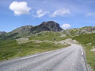 The road with Bitihorn in the background
References
Wikimedia Commons has media related to Fylkesveg 51.
- ↑ "Valdresflye". Norwegian Public Roads Administration. Archived from the original on 8 October 2011. Retrieved 5 October 2011.
- ↑ "Nasjonal turistveg Valdresflye" (in Norwegian). Norwegian Public Roads Administration. Archived from the original on 12 April 2011. Retrieved 5 October 2011.
|  | |
This article is issued from Wikipedia. The text is licensed under Creative Commons - Attribution - Sharealike. Additional terms may apply for the media files.