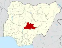
8°22′N 8°46′E / 8.367°N 8.767°E
Obi, Nasarawa State | |
|---|---|
| Nickname: Obi | |
 Obi, Nasarawa State | |
| Coordinates: 8°22′N 8°46′E / 8.367°N 8.767°E | |
| Country | |
| State | Nasarawa State |
| Headquarters | Obi |
| Government | |
| • Osuko | Aliyu Dangiwa Ogiri Orume |
| Time zone | UTC+1 (WAT) |
Obi is a Local Government Area in Nasarawa State, Nigeria. Its headquarters are in the town of Obi. it other towns include Adudu Emirate, Agwatashi, Daddare, Jenkwe, Duduguru, Agyaragu, Tudun Adabu, Gude, and Riri.
It has an area of 967 km2 and a population of 148,874 at the 2006 census.
The postal code of the area is 951.[1]
Climate
Temperatures range from 64°F to 96°F, rarely dropping below 58°F or rising beyond 102°F, and the weather is typically partly cloudy and overcast throughout the year.[2][3]
Temperature
Obi experiences high temperatures on a regular basis; March is the hottest month with a high of 96°F.[2]
References
- ↑ "Post Offices- with map of LGA". NiPost. Archived from the original on October 7, 2009. Retrieved 2009-10-20.
- 1 2 "Obi Climate, Weather By Month, Average Temperature (Nigeria) - Weather Spark". weatherspark.com. Retrieved 2023-09-11.
- ↑ "Obi, Nasarawa, NG Climate Zone, Monthly Averages, Historical Weather Data". tcktcktck.org. Retrieved 2023-09-11.
This article is issued from Wikipedia. The text is licensed under Creative Commons - Attribution - Sharealike. Additional terms may apply for the media files.
