Olavakkode
Olavakkot | |
|---|---|
Suburb | |
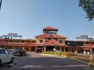
 Palakkad Junction Railway Station | |
| Coordinates: 10°47′0″N 76°38′0″E / 10.78333°N 76.63333°E | |
| Country | |
| State | Kerala |
| District | Palakkad |
| Founded by | Pazhashi Raja |
| Government | |
| • Body | Palakkad Municipality |
| Languages | |
| • Official | Malayalam, English |
| Time zone | UTC+5:30 (IST) |
| PIN | 678002 |
| Telephone code | 0491 |
| Vehicle registration | KL- 9 |
| Nearest city | Palakkad |
| Lok Sabha constituency | Palakkad |
Olavakkode is a region in Palakkad city, Kerala, India. It is composed of two main areas: the Kavilpad and the Railway Colony. Olavakkode is located 4 km from Palakkad city and lies on National Highway 966.It is one of the major suburbs of Palakkad city as Palakkad Junction railway station[1] one of the major stations of the city is located there.
Transport
The main railway station in the city, Palakkad Junction railway station is situated there. It is also the entry point by road from the North Malabar. Olavakkode lies on National Highway 966, which connects Palakkad with Kozhikode via Malappuram. The nearest airport is Coimbatore International Airport.
Economy
During the 2010s many residential developments were built in this area. National Highway 966 connects Palakkad with Kozhikode. Facilities like banks ( including Sunday banking by one of the premier banks), ATMs, shopping places, lodges, hotels, hospitals, dental outlets, and marriage halls are available.

Points of interest
- Palakkad Junction (formerly called Olavakkode Junction)
- Palakkad railway division office
- Divisional Railway Hospital
- Malampuzha Dam and Garden
- Shri Thirupuraikkal Bhagavathy temple
- Thirumananghat Shiva Temple
- Jain Temple
- Previous location of the Broad Gauge Railway junction
- St.Joseph's Forane Church
Image Gallery
 Temple in Olavakkod
 Daiva Sabha Church
 Railway Compound
 Vegetable shop near Catholic Bank
References
- ↑ "ഒലവക്കോട് റെയിൽവേ സ്റ്റേഷനിൽ നൂറടി ഉയരത്തില് ദേശീയപതാക പാറിപ്പറക്കും". ManoramaOnline (in Malayalam). Retrieved 26 June 2022.