Olaya Herrera | |
|---|---|
Municipality and town | |
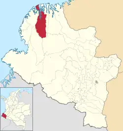
 Location of the municipality and town of Olaya Herrera in the Nariño Department of Colombia. | |
| Coordinates: 2°20′49″N 78°19′32″W / 2.34694°N 78.32556°W | |
| Country | |
| Department | Nariño Department |
| Population (2020 est.[1]) | |
| • Total | 33,132 |
| Time zone | UTC-5 (Colombia Standard Time) |
Olaya Herrera is a town and municipality in the Nariño Department, Colombia. Named after the former President of Colombia Enrique Olaya Herrera. Its municipal seat is known as Bocas de Satinga.
Climate
Olaya Herrera has a tropical rainforest climate (Köppen Af) with heavy to very heavy rainfall year-round.
| Climate data for Bocas de Satinga | |||||||||||||
|---|---|---|---|---|---|---|---|---|---|---|---|---|---|
| Month | Jan | Feb | Mar | Apr | May | Jun | Jul | Aug | Sep | Oct | Nov | Dec | Year |
| Mean daily maximum °C (°F) | 28.6 (83.5) |
29.5 (85.1) |
29.9 (85.8) |
29.8 (85.6) |
29.5 (85.1) |
29.6 (85.3) |
29.4 (84.9) |
29.2 (84.6) |
29.0 (84.2) |
28.3 (82.9) |
28.4 (83.1) |
28.8 (83.8) |
29.2 (84.5) |
| Daily mean °C (°F) | 25.5 (77.9) |
25.9 (78.6) |
26.3 (79.3) |
26.3 (79.3) |
26.2 (79.2) |
26.1 (79.0) |
26.0 (78.8) |
26.0 (78.8) |
25.8 (78.4) |
25.5 (77.9) |
25.6 (78.1) |
25.6 (78.1) |
25.9 (78.6) |
| Mean daily minimum °C (°F) | 22.5 (72.5) |
22.4 (72.3) |
22.7 (72.9) |
22.9 (73.2) |
23.0 (73.4) |
22.6 (72.7) |
22.6 (72.7) |
22.8 (73.0) |
22.6 (72.7) |
22.8 (73.0) |
22.8 (73.0) |
22.5 (72.5) |
22.7 (72.8) |
| Average rainfall mm (inches) | 330 (13.0) |
293 (11.5) |
257 (10.1) |
348 (13.7) |
502 (19.8) |
489 (19.3) |
320 (12.6) |
264 (10.4) |
346 (13.6) |
329 (13.0) |
254 (10.0) |
231 (9.1) |
3,963 (156.1) |
| Source: Climate-Data.org[2] | |||||||||||||
References
- ↑ "Resultados y proyecciones (2005-2020) del censo 2005". Retrieved 19 April 2020.
- ↑ "Climate: Bocas de Satinga". Climate-Data.org. Retrieved October 14, 2020.
This article is issued from Wikipedia. The text is licensed under Creative Commons - Attribution - Sharealike. Additional terms may apply for the media files.