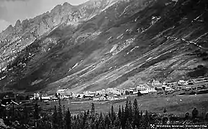
Ophir, Colorado | |
|---|---|
 Ophir, Colorado, around 1900 | |
 Location of Ophir in San Miguel County, Colorado. | |
| Coordinates: 37°51′22″N 107°49′52″W / 37.85611°N 107.83111°W | |
| Country | |
| State | |
| County[1] | San Miguel |
| Government | |
| • Type | Home rule municipality[1] |
| Area | |
| • Total | 0.23 sq mi (0.61 km2) |
| • Land | 0.23 sq mi (0.61 km2) |
| • Water | 0.00 sq mi (0.00 km2) |
| Elevation | 9,695 ft (2,955 m) |
| Population | |
| • Total | 197 |
| • Density | 860/sq mi (320/km2) |
| Time zone | UTC-7 (Mountain (MST)) |
| • Summer (DST) | UTC-6 (MDT) |
| ZIP code[5] | 81426 (PO Box) |
| Area code | 970 |
| FIPS code | 08-55870 |
| GNIS feature ID | 0187505 |
| Highways | none |
| Website | Official website |
Ophir is a home rule municipality town governed by a general assembly and is located in San Miguel County, Colorado, United States. It is located two miles from the Ames Hydroelectric Generating Plant, the world's first hydroelectric plant to supply alternating current electricity for an industrial purpose (mining). The population was 197 at the 2020 census.[4]
History
A post office called Ophir was established in 1878.[6] The town was named after Ophir, a place mentioned in the Hebrew Bible.[7]
Geography
.JPG.webp)
Ophir is located at 37°51′22″N 107°49′52″W / 37.85611°N 107.83111°W (37.856049, -107.831167).[8]
According to the United States Census Bureau, the town has a total area of 0.2 square miles (0.52 km2), all land.
Demographics
| Census | Pop. | Note | %± |
|---|---|---|---|
| 1880 | 130 | — | |
| 1890 | 113 | −13.1% | |
| 1900 | 127 | 12.4% | |
| 1910 | 124 | −2.4% | |
| 1940 | 2 | — | |
| 1950 | 2 | 0.0% | |
| 1970 | 6 | — | |
| 1980 | 38 | 533.3% | |
| 1990 | 69 | 81.6% | |
| 2000 | 113 | 63.8% | |
| 2010 | 159 | 40.7% | |
| 2020 | 197 | 23.9% |
Climate
Climate type is dominated by the winter season, a long, bitterly cold period with short, clear days, relatively little precipitation mostly in the form of snow, and low humidity. The Köppen Climate Classification sub-type for this climate is "Dfc" (Continental Subarctic Climate).[9]
| Climate data for Ophir, Colorado | |||||||||||||
|---|---|---|---|---|---|---|---|---|---|---|---|---|---|
| Month | Jan | Feb | Mar | Apr | May | Jun | Jul | Aug | Sep | Oct | Nov | Dec | Year |
| Record high °F (°C) | 64 (18) |
60 (16) |
68 (20) |
71 (22) |
82 (28) |
96 (36) |
93 (34) |
92 (33) |
88 (31) |
78 (26) |
68 (20) |
65 (18) |
96 (36) |
| Mean daily maximum °F (°C) | 34 (1) |
37 (3) |
41 (5) |
47 (8) |
57 (14) |
68 (20) |
73 (23) |
71 (22) |
64 (18) |
54 (12) |
42 (6) |
33 (1) |
51.8 (11.0) |
| Mean daily minimum °F (°C) | −4 (−20) |
0 (−18) |
8 (−13) |
18 (−8) |
28 (−2) |
33 (1) |
39 (4) |
39 (4) |
31 (−1) |
22 (−6) |
9 (−13) |
−2 (−19) |
18.4 (−7.6) |
| Record low °F (°C) | −38 (−39) |
−38 (−39) |
−25 (−32) |
−18 (−28) |
0 (−18) |
10 (−12) |
20 (−7) |
0 (−18) |
5 (−15) |
−12 (−24) |
−23 (−31) |
−35 (−37) |
−38 (−39) |
| Average rainfall inches (mm) | 1.77 (45) |
2.24 (57) |
2.38 (60) |
1.92 (49) |
1.73 (44) |
1.20 (30) |
2.59 (66) |
3.28 (83) |
3.23 (82) |
2.37 (60) |
1.82 (46) |
2.04 (52) |
26.57 (674) |
| Source: Weather.com[10] | |||||||||||||
Points of interest
See also
- List of municipalities in Colorado
- San Juan Mountains
- Araiza, Caroline. 2023. "Ophir Rides out the Slides," Colorado Life, January/February 2023, pp. 52–58.
References
- 1 2 "Active Colorado Municipalities". State of Colorado, Department of Local Affairs. Archived from the original on December 12, 2009. Retrieved September 1, 2007.
- ↑ "2019 U.S. Gazetteer Files". United States Census Bureau. Retrieved July 1, 2020.
- ↑ "US Board on Geographic Names". United States Geological Survey. October 25, 2007. Retrieved January 31, 2008.
- 1 2 United States Census Bureau. "Ophir town, Colorado". Retrieved April 5, 2023.
- ↑ "ZIP Code Lookup". United States Postal Service. Archived from the original (JavaScript/HTML) on November 4, 2010. Retrieved November 27, 2007.
- ↑ "Post offices". Jim Forte Postal History. Retrieved July 6, 2016.
- ↑ Dawson, John Frank. Place names in Colorado: why 700 communities were so named, 150 of Spanish or Indian origin. Denver, CO: The J. Frank Dawson Publishing Co. p. 38.
- ↑ "US Gazetteer files: 2010, 2000, and 1990". United States Census Bureau. February 12, 2011. Retrieved April 23, 2011.
- ↑ Climate Summary for Ophir, Colorado
- ↑ "weather.com". Retrieved September 17, 2020.
External links
 Media related to Ophir, Colorado at Wikimedia Commons
- Official website
- CDOT map of the Town of Ophir
- The last passenger train on the Ophir Trestle, September 2, 1951. Accessed 5/30/2020
