| Osse | |
|---|---|
.JPG.webp) | |
  | |
| Location | |
| Country | France |
| Physical characteristics | |
| Source | |
| • location | Plateau de Lannemezan |
| • coordinates | 43°20′18″N 00°19′37″E / 43.33833°N 0.32694°E |
| • elevation | 350 m (1,150 ft) |
| Mouth | |
• location | Gélise |
• coordinates | 44°07′15″N 00°16′49″E / 44.12083°N 0.28028°E |
• elevation | 42 m (138 ft) |
| Length | 120.3 km (74.8 mi) |
| Basin size | 600 km2 (230 sq mi) |
| Discharge | |
| • average | 2.62 m3/s (93 cu ft/s) |
| Basin features | |
| Progression | Gélise→ Baïse→ Garonne→ Gironde estuary→ Atlantic Ocean |
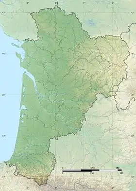
The Osse (French pronunciation: [ɔs]) is a 120 km (75 mi) long river in southwestern France, right tributary of the river Gélise.[1] Its source is in the Hautes-Pyrénées, 2 km (1.2 mi) southeast of the village Bernadets-Debat, in the Plateau de Lannemezan. It joins the river Gélise 5 km (3.1 mi) southwest of the town Nérac.
Its course crosses the following départements and communes:
References
This article is issued from Wikipedia. The text is licensed under Creative Commons - Attribution - Sharealike. Additional terms may apply for the media files.