Tuntenhausen | |
|---|---|
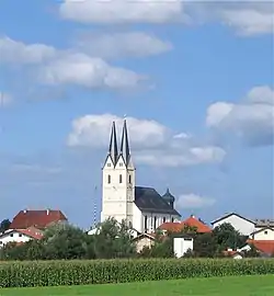
 Church of the Assumption of the Virgin Mary | |
 Coat of arms | |
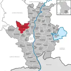
Location of Tuntenhausen within Rosenheim district  | |
 Tuntenhausen  Tuntenhausen | |
| Coordinates: 47°56′N 12°01′E / 47.933°N 12.017°E | |
| Country | Germany |
| State | Bavaria |
| Admin. region | Oberbayern |
| District | Rosenheim |
| Government | |
| • Mayor (2020–26) | Georg Weigl[1] (CSU) |
| Area | |
| • Total | 68.98 km2 (26.63 sq mi) |
| Elevation | 508 m (1,667 ft) |
| Population (2022-12-31)[2] | |
| • Total | 7,454 |
| • Density | 110/km2 (280/sq mi) |
| Time zone | UTC+01:00 (CET) |
| • Summer (DST) | UTC+02:00 (CEST) |
| Postal codes | 83104 |
| Dialling codes | 08067, 08065 (Schönau) |
| Vehicle registration | RO |
| Website | www.tuntenhausen.de |
Tuntenhausen is a municipality in the district of Rosenheim in Bavaria in Germany.
There are 57 official districts of Tuntenhausen, namely Tuntenhausen itself, Antersberg, Aubenhausen, Bach, Berg, Beyharting, Biberg, Bichl (this Bichl is an Einöde), Bichl (this Bichl is a Weiler (hamlet)), Bolkam, Brettschleipfen, Dettendorf, Eggarten, Eisenbartling, Emling, Fischbach, Fuchsholz, Großrain, Guperding, Haus, Höglhaus, Hohenthann, Holzbichl, Hopfen, Hörmating, Innerthann, Jakobsberg, Karlsried, Knogl, Kronbichl, Lampferding, Mailling, Maxlrain, Moosmühle, Mühlholz, Neureith, Nordhof, Oberrain, Oed, Ostermünchen, Pangraz, Schlafthal, Schmidhausen, Schönau, Schwaig, Schweizerberg, Schweizerting, Seisrain, Sindlhausen, Söhl, Stetten (this Stetten is a Dorf (village)), Stetten (this Stetten is an Einöde), Thal, Unterrain, Voglried, Weiching, Weng.[3]
Ostermünchen is a station of the Munich–Rosenheim railway and served about once per hour by local trains.[4]
The town is known best for its church, a destination for Roman Catholic pilgrims in Bavaria.
The name of the town translates to "sissy town" or "fag town" what makes it sound funny to some German-speakers.[5]
References
- ↑ Liste der ersten Bürgermeister/Oberbürgermeister in kreisangehörigen Gemeinden, Bayerisches Landesamt für Statistik, 15 July 2021.
- ↑ Genesis Online-Datenbank des Bayerischen Landesamtes für Statistik Tabelle 12411-003r Fortschreibung des Bevölkerungsstandes: Gemeinden, Stichtag (Einwohnerzahlen auf Grundlage des Zensus 2011)
- ↑ Bayerische Landesbibliothek Online
- ↑ See schedule at the Meridian site
- ↑ "Das sind die irrsten Ortsnamen Deutschlands". bild.de (in German). 2014-08-01. Retrieved 2021-10-14.