Otwell, Indiana | |
|---|---|
 | |
 Location of Otwell in Pike County, Indiana. | |
| Coordinates: 38°27′24″N 87°05′45″W / 38.45667°N 87.09583°W | |
| Country | United States |
| State | Indiana |
| County | Pike |
| Township | Jefferson |
| Named for | Robert Otwell Brown |
| Area | |
| • Total | 1.79 sq mi (4.63 km2) |
| • Land | 1.78 sq mi (4.62 km2) |
| • Water | 0.00 sq mi (0.01 km2) |
| Elevation | 499 ft (152 m) |
| Population (2020) | |
| • Total | 396 |
| • Density | 221.85/sq mi (85.67/km2) |
| Time zone | UTC-5 (Eastern (EST)) |
| • Summer (DST) | UTC-4 (EDT) |
| ZIP code | 47564 |
| Area code(s) | 812, 930 |
| FIPS code | 18-57384[3] |
| GNIS feature ID | 2629881[2] |
Otwell is an unincorporated census-designated place in Jefferson Township, Pike County, in the U.S. state of Indiana.[2]
History
Otwell was originally called Pierceville, being named after President Franklin Pierce, and under this name was laid out in 1855.[4] The name was changed to Otwell in 1864 by a popular petition of its residents. The name had to be changed when the post office came because there was already a Pierceville in Indiana.[4] The name Otwell is derived from the middle name of Robert Otwell Brown, the son of an early settler.[5]
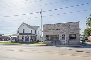
A post office has been in operation at Otwell since 1864.[6]
Geography
Otwell is located along Indiana State Road 257 and is approximately 1 mile from Indiana State Road 56.
Education
Otwell has a public library, a branch of the Pike County Public Library.[7]
Otwell has a charter school which was established in 2017 after the local school corporation closed its elementary school. Otwell Miller Academy currently enrolls 88 students for the 2018/19 school year. Grace College sponsors the charter.
Demographics
| Census | Pop. | Note | %± |
|---|---|---|---|
| 2020 | 396 | — | |
| U.S. Decennial Census[8] | |||
References
- ↑ "2020 U.S. Gazetteer Files". United States Census Bureau. Retrieved March 16, 2022.
- 1 2 3 U.S. Geological Survey Geographic Names Information System: Otwell, Indiana
- ↑ "U.S. Census website". United States Census Bureau. Retrieved January 31, 2008.
- 1 2 History of Pike and Dubois Counties, Indiana. Goodspeed Brothers. p. 356. ISBN 978-5-87521-222-2.
- ↑ Baker, Ronald L. (October 1995). From Needmore to Prosperity: Hoosier Place Names in Folklore and History. Indiana University Press. p. 254. ISBN 978-0-253-32866-3.
...Robert Otwell Brown, son of Dr. Perry Brown, who laid out the village.
- ↑ "Pike County". Jim Forte Postal History. Retrieved February 26, 2017.
- ↑ "Hours of Operation". Pike County Public Library. Retrieved March 14, 2018.
- ↑ "Census of Population and Housing". Census.gov. Retrieved June 4, 2016.