Ouro | |
|---|---|
Municipality | |
| The Municipality of Ouro | |
 Flag  Seal | |
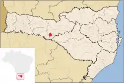
 Location of Ouro in Santa Catarina state | |
| Coordinates: 27°19′51″S 51°35′57″W / 27.33083°S 51.59917°W | |
| Country | |
| Region | South |
| State | Santa Catarina |
| Founded | April 7, 1961 |
| Government | |
| • Mayor | Neri Luiz Miqueloto (DEM) |
| Area | |
| • Total | 206.229 km2 (79.625 sq mi) |
| Elevation | 485 m (1,591 ft) |
| Population (2020 [1]) | |
| • Total | 7,272 |
| • Density | 35/km2 (91/sq mi) |
| Time zone | UTC-3 (UTC-3) |
| • Summer (DST) | UTC-2 (UTC-2) |
| HDI (2000) | 0.828 – high[2] |
| Website | www.ouro.sc.gov.br |
Ouro is a municipality in the state of Santa Catarina in the South region of Brazil.[3][4]
See also
References
- ↑ IBGE 2020
- ↑ Archived 2009-10-03 at the Wayback Machine - UNDP
- ↑ "Divisão Territorial do Brasil" (in Portuguese). Divisão Territorial do Brasil e Limites Territoriais, Instituto Brasileiro de Geografia e Estatística (IBGE). July 1, 2008. Retrieved December 17, 2009.
- ↑ "Produto Interno Bruto dos Municípios 2002-2005" (PDF) (in Portuguese). Instituto Brasileiro de Geografia e Estatística (IBGE). December 19, 2007. Retrieved December 17, 2009.
This article is issued from Wikipedia. The text is licensed under Creative Commons - Attribution - Sharealike. Additional terms may apply for the media files.
