Palanda Canton | |
|---|---|
 Flag | |
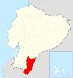
 Location of Zamora Chinchipe Province in Ecuador. | |
.svg.png.webp) Cantons of Zamora Chinchipe Province | |
| Coordinates: 4°38′59″S 79°07′56″W / 4.6498°S 79.1321°W | |
| Country | |
| Province | Zamora-Chinchipe Province |
| Capital | Palanda |
| Time zone | UTC-5 (ECT) |
Palanda Canton is a canton of Ecuador, located in the Zamora-Chinchipe Province. Its capital is the town of Palanda. Its population at the 2001 census was 7,066.[1]
History
This canton has a long history, from the earliest known humans occupation[2] to one of the latest inca battle, just before the colonial time.[3]
Parishes
The canton is administratively divided into 4 parishes
- Vergel
- Palanda
- El Porvenir
- Valladolid
Archaeology
The site of Santa Ana (La Florida) is located just to the north of Palanda.[4] This is an important archaeological site going back as early as 3,500 BC.
The work in this area was started in 2002 by a team of French and Ecuadoran archaeologists.
References
- ↑ Cantons of Ecuador at statoids.com
- ↑ "Mayo-Chinchipe - Proyecto Zamora Chinchipe". Archived from the original on 2014-11-29. Retrieved 2010-05-27.
- ↑ "San Agustín - Proyecto Zamora Chinchipe". Archived from the original on 2013-10-01. Retrieved 2010-05-27.
- ↑ area map
Bibliography
- Human settlements already existed in the Amazon Basin (Ecuador) 4000 years ago. 12-May-2004 eurekalert.org
- Valdez, Francisco. “Inter-zonal relationships in Ecuador”, en Handbook of South American Archaeology, Helaine Silverman y William Isbell eds., Springer, pp. 865–891, 2008
- Valdez, Francisco; Jean Gufroy; Geoffroy de Saulieu; Julio Hurtado; Alexandra Yépez (2005), Découverte d’un site cérémoniel formatif sur le versant oriental des Andes Proyecto Zamora Chinchipe
This article is issued from Wikipedia. The text is licensed under Creative Commons - Attribution - Sharealike. Additional terms may apply for the media files.