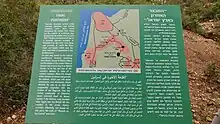
Palestine Final Fortress was the British 1942 defence plan for Mandatory Palestine at World War II against a possible German invasion from the north.
History
During World War II, Mandatory Palestine twice faced the danger of invasion by the German army and its allies. The first began when Nazi Germany conquered France in June 1940 and the rise of the pro-Nazi regime of Vichy France, which controlled Lebanon and Syria. This made the possibility of a German invasion from the north highly probable. That summer, the British armed forces started preparing a defence line against invasions from the north.
The following year, between June and July 1941, the British captured Lebanon and Syria from Vichy France. However, this had not removed the threat of a major German invasion from the north, as the British believed that the Red Army might not hold the line against Nazi Germany. Even though the defence line in the Soviet Union had been stabilized, the British made a strategic plan for the retreating troops out of Syria to be assembled in the mountainous region between Mount Carmel and the Jordan Rift Valley. This topography was believed to be effective against the Nazi German tank force (Panzerwaffe). This plan was referred to as Palestine Final Fortress (PFF) of "Defence of the Last Position Palestine". In early 1942, the British declared the Mount Carmel region a closed military area and began massive infrastructure work.[1]
In 1942, the threat of a German invasion from the south increased with the Afrika Korps advance into Egypt. Yishuv leaders discussed plans to defend against genocide of the Jewish population by the German army and by local Nazi supporters, which was expected in the event of British retreat from Palestine.[2][3] The Hagana's "Plan of the North" included use of Palestine Final Fortress structures. The Yishuv also called their plan "Masada on the Carmel" and "Haifa-Masada-Musa Dagh".[4] Although the Yishuv had cause for worry during the 200 days of dread, no further actions were taken by the British nor by the Yishuv to prepare against possible invasion by the Axis powers. In late 1942, the threat of invasion from the south was lifted following the Allied victory in the Second Battle of El Alamein and the subsequent German retreat westwards across North Africa.
See also
References
- ↑ Sharfman, Daphna (2014). Palestine in the Second World War: Strategic Plans and Political Dilemmas. Eastbourne, UK: Sussex Academic Press. p. 24. ISBN 9781845195267. Retrieved 12 April 2015.
- ↑ Mallmann, Klaus-Michael; Cüppers, Martin (2007). "'Elimination of the Jewish National Home in Palestine': The Einsatzkommando of the Panzer Army Africa, 1942" (PDF). Yad Vashem Studies. 35 (1): 1–31. Archived from the original (PDF) on 2019-08-28. Retrieved 2015-04-12.
- ↑ Klaus-Michael Mallmann and Martin Cüppers. Nazi Palestine: The Plans for the Extermination of the Jews in Palestine. New York: Enigma Books with the United States Holocaust Memorial Museum, 2010.
- ↑ Nachman Ben-Yehuda. Masada Myth: Collective Memory and Mythmaking in Israel. Univ of Wisconsin Press, 1995. p. 133 http://uwpress.wisc.edu/books/0117.htm