Palmeira | |
|---|---|
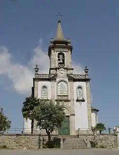
 Palmeira Church | |
 | |
| Coordinates: 41°35′38″N 8°25′44″W / 41.594°N 8.429°W | |
| Country | |
| Region | Norte |
| Intermunic. comm. | Cávado |
| District | Braga |
| Municipality | Braga |
| Area | |
| • Total | 8.88 km2 (3.43 sq mi) |
| Population (2011) | |
| • Total | 5,468 |
| • Density | 620/km2 (1,600/sq mi) |
| Time zone | UTC±00:00 (WET) |
| • Summer (DST) | UTC+01:00 (WEST) |
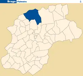
Palmeira is a Portuguese parish, located in the municipality of Braga. The population in 2011 was 5,468,[1] in an area of 8.88 km².[2] It is located near the Cávado river, on the south bank, about 5 mi (8.0 km) north from the historic center of the city of Braga.
Braga Airport (Aérodromo Municipal de Braga)(BGZ) is located in Palmeira. The Circuito Vasco Sameiro is located at the airport.
Main sights
- Dona Chica Castle (Castelo de Dona Chica), from Ernesto Korrodi.
- Cávado rivervalley
References
- ↑ Instituto Nacional de Estatística
- ↑ "Áreas das freguesias, concelhos, distritos e país". Archived from the original on 2018-11-05. Retrieved 2018-11-05.
This article is issued from Wikipedia. The text is licensed under Creative Commons - Attribution - Sharealike. Additional terms may apply for the media files.