Pasvalys District Municipality
Pasvalio rajono savivaldybė | |
|---|---|
 Migoniai mound | |
 Coat of arms | |
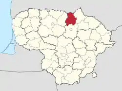 Location of Pasvalys district municipality within Lithuania | |
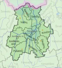 Map of Pasvalys district municipality | |
| Country | |
| Ethnographic region | Aukštaitija |
| County | |
| Capital | Pasvalys |
| Elderships | 11 |
| Area | |
| • Total | 1,289 km2 (498 sq mi) |
| • Rank | 27th |
| Population (2021[1]) | |
| • Total | 23,148 |
| • Rank | 36th |
| • Density | 18/km2 (47/sq mi) |
| • Rank | 37th |
| Time zone | UTC+2 (EET) |
| • Summer (DST) | UTC+3 (EEST) |
| Telephone code | 451 |
| Major settlements |
|
| Website | www |
Pasvalys District Municipality is one of 60 municipalities in Lithuania.
Structure
District structure:
- 2 cities – Joniškėlis and Pasvalys;
- 7 towns – Daujėnai, Krikliniai, Krinčinas, Pumpėnai, Pušalotas, Saločiai and Vaškai;
- 398 villages.
Population of largest elderships of Pasvalys District Municipality (2001):
References

This article is issued from Wikipedia. The text is licensed under Creative Commons - Attribution - Sharealike. Additional terms may apply for the media files.