Patambuco | |
|---|---|
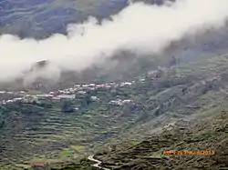 Patambuco as seen from Kuntur Sinqa | |
| Country | |
| Region | Puno |
| Province | Sandia |
| Capital | Patambuco |
| Government | |
| • Mayor | Angel Silvestre Ochoa Colque |
| Area | |
| • Total | 462.72 km2 (178.66 sq mi) |
| Elevation | 3,588 m (11,772 ft) |
| Population | |
| • Total | 4,833 |
| • Density | 10/km2 (27/sq mi) |
| Time zone | UTC-5 (PET) |
| UBIGEO | 211204 |
Patambuco District is one of ten districts of the Sandia Province in Peru.[1]
Geography
One of the highest elevations of the district is Q'alawaña at 5,325 m (17,470 ft). Other mountains are listed below:[2]
- Ch'usiqani
- Hatun Apachita
- Hatun Pinkilluni
- Huch'uy Apachita
- Huch'uy Pinkilluni
- Janq'u Qala
- Jiwaña
- Kimsa Chata
- Maran Sarani
- Mulli P'unqu
- Pinkilluni
- Pirwani
- Pukara
- Phaqcha Pata
- Qaqa Wasi
- Qayqu Tira
- Qutaña Urqu
- Q'alawaña
- Q'asa
- Rit'i Chaki
- Rit'i Kunka
- Rit'i K'uchu
- Surayuq
- Warachani
- Yana Qaqa
Ethnic groups
The people in the district are mainly indigenous citizens of Quechua descent. Quechua is the language which the majority of the population (89.65%) learnt to speak in childhood, 9.77% of the residents started speaking using the Spanish language (2007 Peru Census).[3]
See also
References
- ↑ (in Spanish) Instituto Nacional de Estadística e Informática. Banco de Información Distrital Archived 2008-04-23 at the Wayback Machine. Retrieved April 11, 2008.
- ↑ escale.minedu.gob.pe - UGEL maps of the Sandia Province, Puno Region
- ↑ inei.gob.pe Archived 2013-01-27 at the Wayback Machine INEI, Peru, Censos Nacionales 2007, Frequencias: Preguntas de Población: Idioma o lengua con el que aprendió hablar (in Spanish)
| |
|---|---|
| Azángaro | |
| Carabaya | |
| Chucuito | |
| El Collao | |
| Huancané | |
| Lampa | |
| Melgar | |
| Moho | |
| Puno | |
| San Antonio de Putina | |
| San Román | |
| Sandia | |
| Yunguyo | |
This article is issued from Wikipedia. The text is licensed under Creative Commons - Attribution - Sharealike. Additional terms may apply for the media files.