| Penchennerie | |
|---|---|
.JPG.webp) | |
  | |
| Location | |
| Country | France |
| Physical characteristics | |
| Source | |
| • location | Haute-Vienne |
| Mouth | |
• location | Auvézère |
• coordinates | 45°25′33″N 1°16′27″E / 45.42583°N 1.27417°E |
| Length | 10 km (6.2 mi) |
| Basin features | |
| Progression | Auvézère→ Isle→ Dordogne→ Gironde estuary→ Atlantic Ocean |
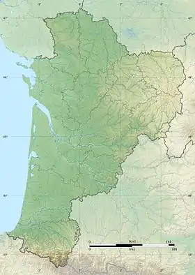
The Penchennerie is a stream in southwestern France. It is a tributary of the river Auvézère, which is part of the Dordogne basin. It is 10.4 km (6.5 mi) long.[1]
The river begins in the commune of Coussac-Bonneval in the Haute-Vienne department, passes through the Corrèze department near Saint-Éloy-les-Tuileries, and flows into the Auvézère in the Dordogne department, northeast of Payzac.
References
This article is issued from Wikipedia. The text is licensed under Creative Commons - Attribution - Sharealike. Additional terms may apply for the media files.