Perry Township | |
|---|---|
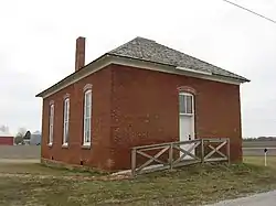 Former Howard School in eastern Perry Township | |
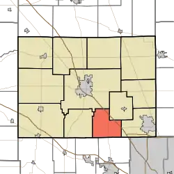 Location of Perry Township in Boone County | |
| Coordinates: 39°56′57″N 86°24′28″W / 39.94917°N 86.40778°W | |
| Country | United States |
| State | Indiana |
| County | Boone |
| Government | |
| • Type | Indiana township |
| Area | |
| • Total | 20.84 sq mi (54.0 km2) |
| • Land | 20.82 sq mi (53.9 km2) |
| • Water | 0.02 sq mi (0.05 km2) |
| Elevation | 948 ft (289 m) |
| Population (2010) | |
| • Total | 1,163 |
| • Density | 55.8/sq mi (21.5/km2) |
| FIPS code | 18-58968[2] |
| GNIS feature ID | 453716 |
Perry Township is one of twelve townships in Boone County, Indiana. As of the 2010 census, its population was 1,163 and it contained 461 housing units.[3]
History
Howard School was listed on the National Register of Historic Places in 2009.[4]
Geography
According to the 2010 census, the township has a total area of 20.84 square miles (54.0 km2), of which 20.82 square miles (53.9 km2) (or 99.90%) is land and 0.02 square miles (0.052 km2) (or 0.10%) is water.[3]
Unincorporated towns
Adjacent townships
- Center (northwest)
- Eagle (east)
- Harrison (west)
- Worth (northeast)
- Brown Township, Hendricks County (southeast)
- Middle Township, Hendricks County (southwest)
Major highways
Cemeteries
The township contains three cemeteries: Dickerson, Howard and Smith.
References
- ↑ "US Board on Geographic Names". United States Geological Survey. October 25, 2007. Retrieved January 31, 2008.
- ↑ "U.S. Census website". United States Census Bureau. Retrieved January 31, 2008.
- 1 2 "Population, Housing Units, Area, and Density: 2010 - County -- County Subdivision and Place -- 2010 Census Summary File 1". United States Census. Archived from the original on February 12, 2020. Retrieved May 10, 2013.
- ↑ "National Register Information System". National Register of Historic Places. National Park Service. July 9, 2010.
External links
Wikimedia Commons has media related to Perry Township, Boone County, Indiana.
Municipalities and communities of Boone County, Indiana, United States | ||
|---|---|---|
| City | Map of Indiana highlighting Boone County | |
| Towns | ||
| Townships | ||
| CDP | ||
| Other communities | ||
| Footnotes | ‡This populated place also has portions in an adjacent county or counties | |
This article is issued from Wikipedia. The text is licensed under Creative Commons - Attribution - Sharealike. Additional terms may apply for the media files.