| Phantom Peak | |
|---|---|
 Phantom Peak Location in Washington  Phantom Peak Location in the United States | |
| Highest point | |
| Elevation | 8,000+ ft (2,440+ m)[1] |
| Prominence | 360 ft (110 m)[1] |
| Coordinates | 48°49′08″N 121°20′33″W / 48.81889°N 121.34250°W[2] |
| Geography | |
| Location | Whatcom County, Washington, U.S. |
| Parent range | Cascade Range |
| Topo map | USGS Mount Challenger |
| Climbing | |
| First ascent | 1940 Fred Beckey |
| Easiest route | Southwest Route Class 4 |
Phantom Peak (8,000+ ft (2,440+ m)) is in North Cascades National Park in the U.S. state of Washington.[3] Located in the northern section of the park, Phantom Peak is in the Picket Range and is 1 mi (1.6 km) northwest of Mount Fury, 1.5 mi (2.4 km) north of Mount Crowder, and .50 mi (0.80 km) south of Crooked Thumb Peak.
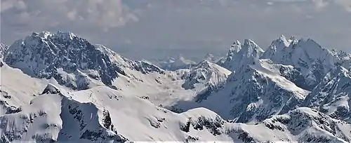
Phantom Peak to left, Mount Crowder to right with McMillan Spires and Mount Terror behind it. Viewed from Ruth Mountain looking east-southeast.
References
- 1 2 "Phantom Peak, Washington". Peakbagger.com. Retrieved July 20, 2013.
- ↑ "Phantom Peak". Geographic Names Information System. United States Geological Survey, United States Department of the Interior. Retrieved July 20, 2013.
- ↑ Mount Challenger, WA (Map). TopoQwest (United States Geological Survey Maps). Retrieved July 20, 2013.
External links
- Phantom Peak aerial photo: PBase
This article is issued from Wikipedia. The text is licensed under Creative Commons - Attribution - Sharealike. Additional terms may apply for the media files.