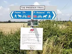
| The Phoenix Trail | |
|---|---|
 | |
| Length | 7 mi (11 km) |
| Location | Buckinghamshire and Oxfordshire |
| Trailheads | Thame 51°44′46″N 0°58′34″W / 51.7461°N 0.9761°W Princes Risborough 51°43′28″N 0°49′56″W / 51.7244°N 0.8323°W |
| Use | Hiking, Cycling |
The Phoenix Trail is a 7-mile (11 km) footpath and cycleway which runs between the market towns of Thame in South Oxfordshire and Princes Risborough in Buckinghamshire, passing through the villages of Towersey and Bledlow.
History
The trail largely follows the route of a disused railway line, the Wycombe Railway, which connected Princes Risborough and Thame with the city of Oxford. The line through Thame remained open until 1991 to serve an oil depot based in the town. It was subsequently purchased by Sustrans and converted into a cycle/pedestrian route.[1]
The Phoenix Trail forms part of National Cycle Route 57 which also includes the Nicky Line and Ayot Greenway rail trails. As well as cyclists and walkers, the route is suitable for wheelchair and pushchair users, as it is flat and surfaced with seating every 500 metres. The first 2.5 miles (4.0 km) out of Thame are surfaced with tarmac and the remainder with compacted limestone dust. Red kites can commonly be seen along the route. There is a collection of 30 sculptures built by Angus Ross and six furniture students from Thame's Rycotewood College, which draw on the trail's railway heritage and the landscape towards the Chiltern Hills. These sculptures won the 2002 "Arts, Business & Community" Award from Arts & Business, and the trail also holds a Certificate of Distinction as a European Greenway from the European Commission.
In June 2008, an extension of the Phoenix Trail to Lord Williams's School (51°44′47″N 0°59′22″W / 51.7465°N 0.9895°W) was officially opened.[2]
See also
References
- ↑ South Oxfordshire Local Plan 2011 (January 2006), para. 12.4
- ↑ "Edinburgh Bicycle Cooperative, "Final Link of the Phoenix Cycling Trail in South Oxfordshire is Officially Opened", 9 June 2008". Archived from the original on 8 October 2011. Retrieved 3 November 2018.