| Phu Thok | |
|---|---|
| ภูทอก | |
 | |
| Highest point | |
| Elevation | 359 m (1,178 ft) |
| Listing | List of mountains in Thailand |
| Coordinates | 18°8′15″N 103°52′45″E / 18.13750°N 103.87917°E |
| Geography | |
 Phu Thok Location in Thailand | |
| Location | Bueng Kan, Thailand |
| Geology | |
| Mountain type | Inselberg |
| Climbing | |
| Easiest route | drive and walk[1] |
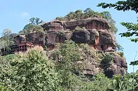
Phu Thok (ภูทอก, also spelled Phu Tok), meaning 'lonely mountain' in the Isan language, is a 359 m high isolated hill in the northeastern end of Isan, Thailand. It is in Na Sabaeng Subdistrict, Si Wilai District, at the centre of Bueng Kan Province.
Geography
Phu Thok is an emblematic sandstone outcrop that is both a local landmark and the symbol of the province of Bueng Kan. It appears in somewhat stylized form in the provincial seal.[2]
Phu Thok has two peaks, Phu Thok Yai and Phu Thok Noi.[3] Wat Phu Thok, an important Buddhist temple, is in a cave near the top of the smaller peak.[4] The summit of this massive rocky hill can be reached via a wooden walkway. The top has views of the surrounding flat countryside.[5]
 Provincial seal of Bueng Kan featuring Phu Thok |
 Walkway and landscape on the north side |
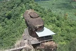 Rock formation from the summit |
See also
References
External links
 Media related to Phu Tok at Wikimedia Commons
- Bueng Kan - Tourism Thailand
- Wat Phu Tok and surroundings
This article is issued from Wikipedia. The text is licensed under Creative Commons - Attribution - Sharealike. Additional terms may apply for the media files.